Syslor Implantation
100+
Downloads

Everyone
info


About this app
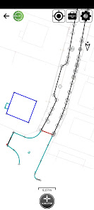
Coupled to the Syslor Proteus GNSS receiver, this application for site managers allows simple and fast topographical operations. The modules integrated in the application are:
• Topographical surveying features (points/polylines/circles/rectangles/…) and for export to DXF and CSV formats.
• Implantation points and lines from a DXF/DWG file
• Earthworks of reference surfaces from a DXF/DWG file
Additional features:
• Ability to set background to DXF/DWG formats
• Management of topographic coordinate systems
Prerequisites to use the application are:
• A Syslor portal account (https://portalsyslor.com/fr)
• A Syslor Proteus GNSS receiver
• A standard subscription "Survey App"
Questions? Contact us (https://syslor.net/en/contact-us/)
Updated on
Safety starts with understanding how developers collect and share your data. Data privacy and security practices may vary based on your use, region, and age. The developer provided this information and may update it over time.

No data shared with third parties
Learn more about how developers declare sharing

This app may collect these data types
Location, Personal info, and App activity

Data isn’t encrypted
Data can’t be deleted
What's new
Improvements and bug fixes


