
PocketTransit
4.7star
90 reviews
10K+
Downloads

Rated for 3+
info
About this app
PocketTransit is a geological compass app for smartphones and tablets, and records the orientations of planes (strike and dip) and lines (trend and plunge), along with traverse angles and field site locations. Built for professional use by geologists, geophysicists, surveyors, and field/mining engineers, PocketTransit allows visualisation of captured data in tabular, map, and stereonet forms, and allows easy export of data to spreadsheet-compatible files. PocketTransit captures strike, dip, trend, plunge and location data simultaneously in one operation.
PocketTransit has a five-tab UI featuring compass, theodolite, project, stereonet, and map pages.
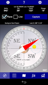
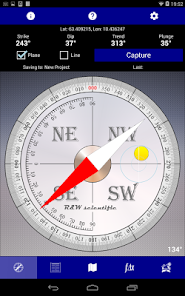
Compass page: displays compass azimuth, along with strike, dip, trend, plunge, and location (in latitude/longitude or UTM), and includes a clinometer display.
Theodolite page: displays horizontal and vertical angles along with location data.
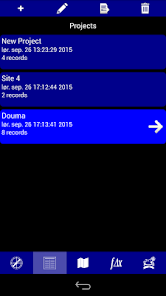
Projects page: displays captured data organised in user-defined projects. Captured data can be reviewed, edited, and exported.
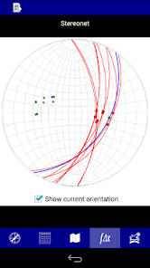
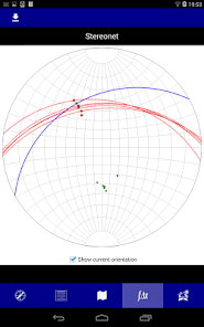
Stereonet page: displays planes, poles, and lineations on a Wulff stereonet. The stereonet image can be exported to file.
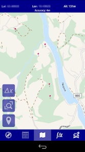
Map page: displays capture locations on a flickable and zoomable map. Standard strike / lineation symbology is used for plane and lineation data.
A more advanced version of PocketTransit - PocketTransitPro - is also available on Google Play and includes extra features such as custom plane and lineation types, photo records, email export, and rose-plot analysis.
Version 1.2.1 is a bug-fix release:
- fix bug updating records when adding and deleting projects
Version 1.2 is mainly a performance and bug-fix release which includes:
- improved rendering of stereonet graphics
- improved handling of capture sound
- improved handling of tab changes
- improved handling of background state of app
- fixed bug with duplicate projects when project name was edited
- fixed some issues with icon sizes on small screens
PocketTransit has a five-tab UI featuring compass, theodolite, project, stereonet, and map pages.
Compass page: displays compass azimuth, along with strike, dip, trend, plunge, and location (in latitude/longitude or UTM), and includes a clinometer display.
Theodolite page: displays horizontal and vertical angles along with location data.
Projects page: displays captured data organised in user-defined projects. Captured data can be reviewed, edited, and exported.
Stereonet page: displays planes, poles, and lineations on a Wulff stereonet. The stereonet image can be exported to file.
Map page: displays capture locations on a flickable and zoomable map. Standard strike / lineation symbology is used for plane and lineation data.
A more advanced version of PocketTransit - PocketTransitPro - is also available on Google Play and includes extra features such as custom plane and lineation types, photo records, email export, and rose-plot analysis.
Version 1.2.1 is a bug-fix release:
- fix bug updating records when adding and deleting projects
Version 1.2 is mainly a performance and bug-fix release which includes:
- improved rendering of stereonet graphics
- improved handling of capture sound
- improved handling of tab changes
- improved handling of background state of app
- fixed bug with duplicate projects when project name was edited
- fixed some issues with icon sizes on small screens
Updated on
Data safety
Developers can show information here about how their app collects and uses your data. Learn more about data safety

No information available
Ratings and reviews
4.7
86 reviews

A Google user
- Flag inappropriate
February 3, 2020
It is a good app for remapping. In order to use its full potential, I meticulously mount it on a rifle scope then placed on a camera tripod. It works like a real transit.
19 people found this review helpful
A Google user
- Flag inappropriate
January 15, 2020
This thing is quick and accurate. It can be used to find location by "shooting" stars, if there is a chart available.
7 people found this review helpful

Ben Dalton
- Flag inappropriate
March 21, 2022
Great simple app
1 person found this review helpful
What's new
Version 1.2.2 is a bug-fix release:
* restored mapping functionality
* restored mapping functionality


