
ProSurvey
10+
Downloads

Everyone
info
About this app
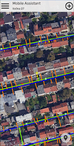
Use external Bluetooth/USB GNSS device to add quickly various elements of your water supply and/or wastewater networks. With high precision GNSS position (up to 1 cm accuracy, if supported by external Bluetooth/USB GNSS device), this application can survey all the essential field attributes needed by an utility company to bring your asset management and digital cadaster, up to speed with real field data.
This mobile application is a part of larger enterprise software system and as such cannot be used as a standalone application. To find out more about our enterprise software system for utility companies and municipalities based on GIS technology please visit our web site at https://protok.com
This mobile application is a part of larger enterprise software system and as such cannot be used as a standalone application. To find out more about our enterprise software system for utility companies and municipalities based on GIS technology please visit our web site at https://protok.com
Updated on
Safety starts with understanding how developers collect and share your data. Data privacy and security practices may vary based on your use, region, and age. The developer provided this information and may update it over time.

No data shared with third parties
Learn more about how developers declare sharing

No data collected
Learn more about how developers declare collection

Data is encrypted in transit

Data can’t be deleted
What's new
Map rendering engine


