
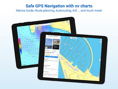
NV Charts GPS Navigation AIS
In-app purchases
3.4star
2K reviews
100K+
Downloads

Everyone
info


About this app
The NV Charts navigation app with an intuitive interface and powerful tools is a must-have for onboard navigation while cruising, fishing, sailing, diving or any other activity on the water. All current editions of the boating charts or maps from NV Charts can be easily downloaded and used for offline navigation with the NV Charts App. All latest editions of NV Charts nautical boating charts or inland charts including | North Sea | Baltic Sea | Netherlands | Wadden Sea | IJsselmeer | Sweden | Denmark | Germany | Norway | France | USA | Caribbean | Bahamas areas are compatible with NV Charts App.
One way to have great nautical charts both on paper and on our phone or tablet is to use our popular combination pack of paper and digital nautical charts, which includes both charts in clever atlas format and a license for digital nautical marine boating charts/maps for use in the NV Charts App, including an update service. The advantage: Both your paper and digital charts are up to date.
In addition you can also purchase digital boating charts as a subscription directly in the NV Charts App. The subscription duration is one year and is automatically extended.
If it is not yet clear where the journey is going to take you, free online charts can be displayed in the app, even without a current subscription or valid paperchart edition.
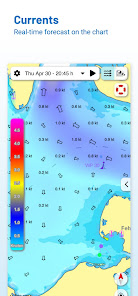
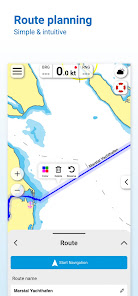
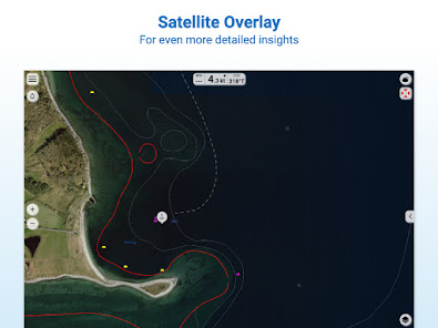
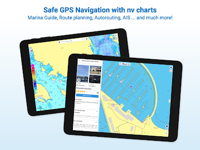
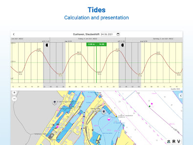
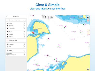
The latest information is essential for safe navigation on the water. With the NV Charts App you have the possibility to become part of the Seame boating community. You can now add marinas, anchorages and navigation warnings to the digital chart and also add and share interesting places beyond navigation, such as restaurants or points of interest with pictures. Others can respond directly with comments. The continuously edited content can be downloaded directly to be available offline. In order to make all information easily accessible, we have improved the search function: You can explore the surroundings and search directly for place names as well as anchorages, harbours, ramps, waypoints, cranes, petrol stations, or tide stations. In addition, an auto-routing function has been integrated, which allows you to navigate directly to your destination.
Together navigation on board is even more fun! You can now share your tracks with friends or use the data outside the app and export it as GPX file. You can share your favorite harbours and anchorages from the app simply by clicking on a link and coordinate your trip planning even better with everyone.
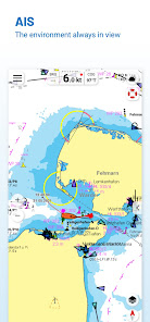
With the AIS function in the NV Charts App you can keep an eye on AIS signals in real-time. You can connect a Wlan AIS receiver to the NV Charts and the app display AIS Class A and B signals and navigation aids (ATON), as well as MOB AIS SART transponder distress transmitters, directly in the digital chart in real-time and the traffic situation can be assessed better.
The NV Charts App can be installed and synchronized on multiple devices.
NV Charts App - Features:
✔ Search function
✔ Autorouting (Europe + other regions following soon)
✔ Velocity Made Good (VMG)
✔ Community Layer / Points of Interest(POI)
✔ Free online boating charts preview for planning
✔ In App Purchases of digital offline charts
✔ Community Layer / Points of Interest(POI)
✔ Reads all NV Chart chart areas
✔ Easy download of the maps
✔ Always the latest data
✔ Seamless zoom and panning functions
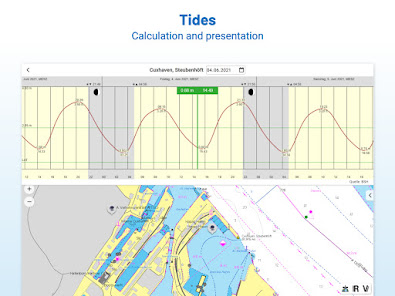
✔ Tide Forecast
✔ Online weather
✔ AIS Wifi Support
✔ AIS Sart Beacon
✔ AIS CPA function
✔ Night mode
✔ Anchor alarm
✔ Position with GPS
✔ Intuitive route planning
✔ Course markings, markings, bearing ruler
✔ Port information
✔ Display of instruments
✔ Synchronizing devices
✔ Live Position Sharing
✔ Social sharing of routes, tracks, positions
## Android version 7.0 or higher required.
Note:
Continued use of GPS in the background can significantly reduce battery life. For hardware compatibility see FAQs on our website
One way to have great nautical charts both on paper and on our phone or tablet is to use our popular combination pack of paper and digital nautical charts, which includes both charts in clever atlas format and a license for digital nautical marine boating charts/maps for use in the NV Charts App, including an update service. The advantage: Both your paper and digital charts are up to date.
In addition you can also purchase digital boating charts as a subscription directly in the NV Charts App. The subscription duration is one year and is automatically extended.
If it is not yet clear where the journey is going to take you, free online charts can be displayed in the app, even without a current subscription or valid paperchart edition.
The latest information is essential for safe navigation on the water. With the NV Charts App you have the possibility to become part of the Seame boating community. You can now add marinas, anchorages and navigation warnings to the digital chart and also add and share interesting places beyond navigation, such as restaurants or points of interest with pictures. Others can respond directly with comments. The continuously edited content can be downloaded directly to be available offline. In order to make all information easily accessible, we have improved the search function: You can explore the surroundings and search directly for place names as well as anchorages, harbours, ramps, waypoints, cranes, petrol stations, or tide stations. In addition, an auto-routing function has been integrated, which allows you to navigate directly to your destination.
Together navigation on board is even more fun! You can now share your tracks with friends or use the data outside the app and export it as GPX file. You can share your favorite harbours and anchorages from the app simply by clicking on a link and coordinate your trip planning even better with everyone.
With the AIS function in the NV Charts App you can keep an eye on AIS signals in real-time. You can connect a Wlan AIS receiver to the NV Charts and the app display AIS Class A and B signals and navigation aids (ATON), as well as MOB AIS SART transponder distress transmitters, directly in the digital chart in real-time and the traffic situation can be assessed better.
The NV Charts App can be installed and synchronized on multiple devices.
NV Charts App - Features:
✔ Search function
✔ Autorouting (Europe + other regions following soon)
✔ Velocity Made Good (VMG)
✔ Community Layer / Points of Interest(POI)
✔ Free online boating charts preview for planning
✔ In App Purchases of digital offline charts
✔ Community Layer / Points of Interest(POI)
✔ Reads all NV Chart chart areas
✔ Easy download of the maps
✔ Always the latest data
✔ Seamless zoom and panning functions
✔ Tide Forecast
✔ Online weather
✔ AIS Wifi Support
✔ AIS Sart Beacon
✔ AIS CPA function
✔ Night mode
✔ Anchor alarm
✔ Position with GPS
✔ Intuitive route planning
✔ Course markings, markings, bearing ruler
✔ Port information
✔ Display of instruments
✔ Synchronizing devices
✔ Live Position Sharing
✔ Social sharing of routes, tracks, positions
## Android version 7.0 or higher required.
Note:
Continued use of GPS in the background can significantly reduce battery life. For hardware compatibility see FAQs on our website
Updated on
Safety starts with understanding how developers collect and share your data. Data privacy and security practices may vary based on your use, region, and age. The developer provided this information and may update it over time.

No data shared with third parties
Learn more about how developers declare sharing

This app may collect these data types
Location, Personal info and 3 others

Data is encrypted in transit
Ratings and reviews
3.5
1.15K reviews

Johannes Goller
- Flag inappropriate
- Show review history
August 21, 2023
The charts are accurate and useful, but the account setting and payment options need significant improvement. I created an account on my mobile 3 years ago and downloaded a chart that since then was updated every year, at nearly 50 EUR. I got charged a day early, and when trying to access the map could not even see it because it was "expired". I also had great difficulties activating the account on a second device. Also, the left-side menu in the app is nonintuitive, and the app generally slow.
6 people found this review helpful

Mark Vandeurzen
- Flag inappropriate
August 16, 2021
At best, the app shows the charts you have purchased (one by one). Syncing of routes and markers between various devices (iOS, Android and MacOS), a rather basic function, does not work... Hilarious that now the app has augmentic reality: they are trying to run before they can walk.... Question is of course if it is even feasible for NVCharts to make a decent digital app: the charts can only be displayed one by one in the app. Basic architecture seems wrong...
22 people found this review helpful
NV CHARTS
April 6, 2022
Hello Mark, apologies for the delayed reply. It seems that maybe the latest version is not installed correctly. As the app should display all charts seamlessly. If the issue is still open, please reach out to us using the feedback function in the app or by email, and we can have a closer look at this to find a solution. I hope this helps already.

Stephanie Seal
- Flag inappropriate
- Show review history
May 13, 2022
The app is great. It definitely makes route planning easy, and fun. The customer support that accompanies the app is bar none. We had a slight issue loading the charts onto my phone and Jessica at NV stepped in and fixed the problem very quickly. Thank you!
8 people found this review helpful
What's new
Improvement of Play Store compatibility


