
Zoom Earth - Live Weather Map
Contains ads
4.4star
35.8K reviews
500K+
Downloads

Rated for 3+
info


About this app
TRACK THE WEATHER IN REAL-TIME
Zoom Earth is an interactive weather map of the world and a real-time hurricane tracker.
Explore the current weather and see forecasts for your location through interactive weather maps of rain, wind, temperature, pressure, and more.
With Zoom Earth, you can track the development of hurricanes, storms, and severe weather, monitor wildfires and smoke, and stay aware of the latest conditions by viewing satellite imagery and rain radar updated in near real‑time.
SATELLITE IMAGERY
Zoom Earth shows weather maps with near real-time satellite imagery. Images are updated every 10 minutes, with a delay between 20 and 40 minutes.
Live satellite images are updated every 10 minutes from NOAA GOES and JMA Himawari geostationary satellites. EUMETSAT Meteosat images are updated every 15 minutes.
HD satellite images are updated twice a day from NASA polar-orbiting satellites Aqua and Terra.
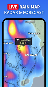
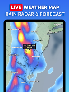
RAIN RADAR & NOWCAST
Stay ahead of the storm with our weather radar map, which shows rain and snow detected by ground-based doppler radar in real-time, and provides an instant short-term weather forecast with radar nowcasting.
WEATHER FORECAST MAPS
Explore beautiful, interactive visualizations of the weather with our stunning global forecast maps. Our maps are continually updated with the latest weather forecast model data from DWD ICON and NOAA/NCEP/NWS GFS. Weather forecast maps include:
Precipitation Forecast - Rain, snow, and cloud cover, all in one map.
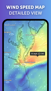
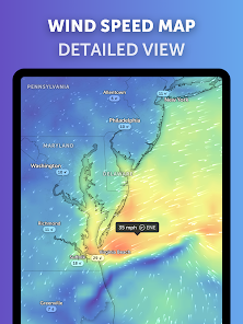
Wind Speed Forecast - Average speed and direction of surface winds.
Wind Gusts Forecast - Maximum speed of sudden bursts of wind.
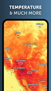
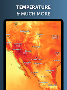
Temperature Forecast - Air temperatures at 2 meters (6 feet) above the ground.
"Feels Like" Temperature Forecast - Perceived temperatures, also known as apparent temperature or heat index.
Relative Humidity Forecast - How air moisture compares to temperature.
Dew Point Forecast - How dry or humid the air feels, and the point at which condensation occurs.
Atmospheric Pressure Forecast - The average atmospheric pressure at sea level. Low-pressure areas often bring cloudy and windy weather. High-pressure areas are associated with clear skies and lighter winds.
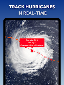
HURRICANE TRACKING
Follow hurricanes from development to category 5 in real-time with our best-in-class tropical tracking system. Information is clear and easy to understand. Our hurricane tracking weather maps are updated using the very latest data from NHC, JTWC, NRL, and IBTrACS.
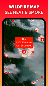
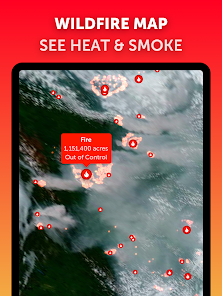
WILDFIRE TRACKING
Monitor wildfires with our active fires and heat spots overlay, which shows points of very high temperature detected by satellite. Detections are updated daily with data from NASA FIRMS. Use in conjunction with our GeoColor satellite imagery to see the movement of wildfire smoke and monitor fire weather in near real-time.
CUSTOMIZATION
Adjust temperature units, wind units, time zone, animation styles, and many more features with our comprehensive settings.
LEGAL
Terms of Service: https://zoom.earth/legal/terms/
Privacy Policy: https://zoom.earth/legal/privacy/
Zoom Earth is an interactive weather map of the world and a real-time hurricane tracker.
Explore the current weather and see forecasts for your location through interactive weather maps of rain, wind, temperature, pressure, and more.
With Zoom Earth, you can track the development of hurricanes, storms, and severe weather, monitor wildfires and smoke, and stay aware of the latest conditions by viewing satellite imagery and rain radar updated in near real‑time.
SATELLITE IMAGERY
Zoom Earth shows weather maps with near real-time satellite imagery. Images are updated every 10 minutes, with a delay between 20 and 40 minutes.
Live satellite images are updated every 10 minutes from NOAA GOES and JMA Himawari geostationary satellites. EUMETSAT Meteosat images are updated every 15 minutes.
HD satellite images are updated twice a day from NASA polar-orbiting satellites Aqua and Terra.
RAIN RADAR & NOWCAST
Stay ahead of the storm with our weather radar map, which shows rain and snow detected by ground-based doppler radar in real-time, and provides an instant short-term weather forecast with radar nowcasting.
WEATHER FORECAST MAPS
Explore beautiful, interactive visualizations of the weather with our stunning global forecast maps. Our maps are continually updated with the latest weather forecast model data from DWD ICON and NOAA/NCEP/NWS GFS. Weather forecast maps include:
Precipitation Forecast - Rain, snow, and cloud cover, all in one map.
Wind Speed Forecast - Average speed and direction of surface winds.
Wind Gusts Forecast - Maximum speed of sudden bursts of wind.
Temperature Forecast - Air temperatures at 2 meters (6 feet) above the ground.
"Feels Like" Temperature Forecast - Perceived temperatures, also known as apparent temperature or heat index.
Relative Humidity Forecast - How air moisture compares to temperature.
Dew Point Forecast - How dry or humid the air feels, and the point at which condensation occurs.
Atmospheric Pressure Forecast - The average atmospheric pressure at sea level. Low-pressure areas often bring cloudy and windy weather. High-pressure areas are associated with clear skies and lighter winds.
HURRICANE TRACKING
Follow hurricanes from development to category 5 in real-time with our best-in-class tropical tracking system. Information is clear and easy to understand. Our hurricane tracking weather maps are updated using the very latest data from NHC, JTWC, NRL, and IBTrACS.
WILDFIRE TRACKING
Monitor wildfires with our active fires and heat spots overlay, which shows points of very high temperature detected by satellite. Detections are updated daily with data from NASA FIRMS. Use in conjunction with our GeoColor satellite imagery to see the movement of wildfire smoke and monitor fire weather in near real-time.
CUSTOMIZATION
Adjust temperature units, wind units, time zone, animation styles, and many more features with our comprehensive settings.
LEGAL
Terms of Service: https://zoom.earth/legal/terms/
Privacy Policy: https://zoom.earth/legal/privacy/
Updated on
Safety starts with understanding how developers collect and share your data. Data privacy and security practices may vary based on your use, region, and age. The developer provided this information and may update it over time.

This app may share these data types with third parties
Location, App activity and 2 others

No data collected
Learn more about how developers declare collection

Data is encrypted in transit

Data can’t be deleted
Ratings and reviews
4.4
35.3K reviews

oPo
- Flag inappropriate
May 7, 2024
Awesome application.Real Time view.Like this app pretty much. Maybe there are some bugs in this app. Please fix those asap. (1> If I enable my location, it has been taking a long time to find out. 2>If I disable my location,It’s showing on, not off.)
1 person found this review helpful

C47CHFHR45E GILMORE
- Flag inappropriate
May 6, 2024
This is the best and my most favourite app I find Zoom Earth very easy to use and the app just keeps getting better and better. Smooth and precise. I also find using Zoom Earth the best way to tell how the weather condition is, yesterday, today, and tomorrow. Reliable and accurate.
3 people found this review helpful
Neave Interactive
May 6, 2024
Thank you so much for your kind review!

CipicU Black
- Flag inappropriate
- Show review history
March 19, 2024
A verry nice app, handy tool if you want to get an idea about the weather. To bad there is no menu for settings to be able to manage it a bit, leike Temp in ⁰C, to have a KM scale to see how farm a clod or fire is from ur location, etc. Overall 4+ No abusive ADDs onbthe app yet. Tnx for assistance, all good now, 5 stars.
42 people found this review helpful
Neave Interactive
March 15, 2024
Glad you like our app! We do have settings - tap the Zoom Earth icon in the upper-left on mobile to access them. Thanks!
What's new
- New! Radar Nowcast. The radar map now shows an instant rain forecast based on real-time data. Coverage is limited.
- Improved Tropical Tracking. Disturbances that are being monitored by the National Hurricane Center are now displayed on the map.
- Other Minor Fixes and Improvements.
- Improved Tropical Tracking. Disturbances that are being monitored by the National Hurricane Center are now displayed on the map.
- Other Minor Fixes and Improvements.


