
Natural Atlas: Trail Map & GPS
In-app purchases
3.9star
88 reviews
10K+
Downloads

Teen
info


About this app
Explore nature in a new way with the ultimate field guide and recorder. Navigate with super-detailed original maps, discover local plants and animals, and build an atlas of your journeys and memories.
If you’re into hiking and nature, Natural Atlas is for you. Filled with practical tools for the hiker, as well as all sorts of inspiring context about the environment you are standing – Natural Atlas is designed to help everyone discover more when out on the trail.
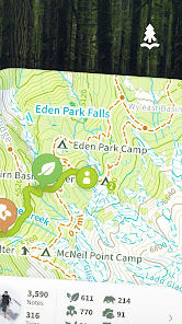
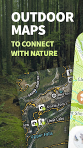
■ ORIGINAL MAPS
Natural Atlas maps are crafted in-house, packed with detail, designed to awaken a spirit of discovery – all available offline.
– 11,000+ Campgrounds
– 359,000+ mi of Trails
– 46,600+ mi of Historic Routes
– 23,000+ Boat Ramps
– Emphasis on Natural Features (Geysers, Hot Springs, Sequoias, etc)
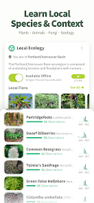
■ LEARN ABOUT YOUR SURROUNDINGS
A field guide of the future that adapts to where you're standing using GPS
– Local Plants, Animals, and Fungi
– Local Geology
– Local Tides / River Levels
– Fish Species by Waterbody
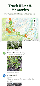
■ RECORD YOUR HIKES
Record Memories & Contribute To Something Bigger In The Process
– Track your path on the map
– Keep track of stats like elevation & distance
– Search for Interesting Details: keep an eye out for things that catch your interest or that you haven’t come across before
– Take Field Notes: snap a photo to save your finding to your catalog of discoveries
– Classify Your Findings: organize your notes by choosing a classification from Natural Atlas’ taxonomy of nature
– Help Build A Better Understanding of Nature: your field notes help map the biodiversity of your ecosystem, improve species suggestions, and improve range maps
■ BUILD YOUR ATLAS
All of your recorded trips and field notes funnel into a rich profile of your times outside that you can look back on and share with friends.
– Notes Organized by Classification
– Customizable Cover Photos
– Ecoregions Explored Map
– Photo Gallery
– Save Places You’ve Been or Want to Visit
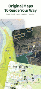
■ GET MORE WITH PLUS SUBSCRIPTION
Upgrade to Natural Atlas Plus (billed yearly) to get the complete Natural Atlas experience. It includes everything you need to navigate and discover while on your next trip outdoors.
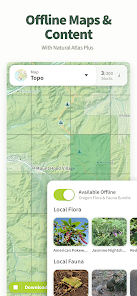
– Download Offline Maps
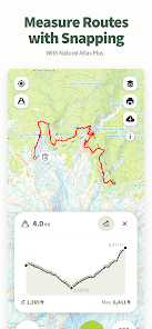
– Measure Routes (Determine distances, snapped to trails and roads on the map)
– Access Premium Maps (USA only)
+ Public Lands Map (based off BLM SMA data) – Shows FS (including inholdings), BLM, NPS, BIA, Bureau of Reclamation, State, and Private - Designed for the Western USA
+ Geology Map – shows geologic formations, faults, and folds
+ Satellite Map – see features of the topo overlaid on top of aerial imagery
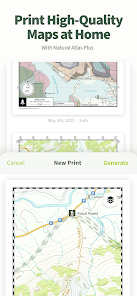
– Generate PDF Maps and print from home
– Unlock all Local Flora and Fauna and download for offline use
– Sunrise, Sunset, Golden Hour Times, Moon Illumination Info
– Private Notes & Trips: Want to note a fishing hole but not publicize it? Mark it as private to make it for your eyes only
– Download GPX Files
– Interactive Range Maps
– Check Latest Tides & River Levels
You can manage your subscription through the Google Play app: https://support.google.com/googleplay/answer/7018481
Subscriptions auto-renew unless turned off at least 24hrs before the end of the current period. Your Google Play account will be charged for renewal within 24hrs prior to the end of the current period, and identify the cost of the renewal
■ CLOUD SYNC
Your recorded trips and notes automatically sync to your Natural Atlas account, available online at NaturalAtlas.com. Review & share your trips online with friends, family, and the Natural Atlas community
■ SUPPORT
hello@naturalatlas.com
■ DISCLAIMERS
[Battery Life] We do everything we can to make the app low power when recording, but GPS is notorious for reducing battery life
[Sensitive Places] Notes of certain sensitive topics like petroglyphs are private by default whether you’ve upgraded to Plus or not
Terms: https://naturalatlas.com/terms
Privacy Policy: https://naturalatlas.com/privacy
If you’re into hiking and nature, Natural Atlas is for you. Filled with practical tools for the hiker, as well as all sorts of inspiring context about the environment you are standing – Natural Atlas is designed to help everyone discover more when out on the trail.
■ ORIGINAL MAPS
Natural Atlas maps are crafted in-house, packed with detail, designed to awaken a spirit of discovery – all available offline.
– 11,000+ Campgrounds
– 359,000+ mi of Trails
– 46,600+ mi of Historic Routes
– 23,000+ Boat Ramps
– Emphasis on Natural Features (Geysers, Hot Springs, Sequoias, etc)
■ LEARN ABOUT YOUR SURROUNDINGS
A field guide of the future that adapts to where you're standing using GPS
– Local Plants, Animals, and Fungi
– Local Geology
– Local Tides / River Levels
– Fish Species by Waterbody
■ RECORD YOUR HIKES
Record Memories & Contribute To Something Bigger In The Process
– Track your path on the map
– Keep track of stats like elevation & distance
– Search for Interesting Details: keep an eye out for things that catch your interest or that you haven’t come across before
– Take Field Notes: snap a photo to save your finding to your catalog of discoveries
– Classify Your Findings: organize your notes by choosing a classification from Natural Atlas’ taxonomy of nature
– Help Build A Better Understanding of Nature: your field notes help map the biodiversity of your ecosystem, improve species suggestions, and improve range maps
■ BUILD YOUR ATLAS
All of your recorded trips and field notes funnel into a rich profile of your times outside that you can look back on and share with friends.
– Notes Organized by Classification
– Customizable Cover Photos
– Ecoregions Explored Map
– Photo Gallery
– Save Places You’ve Been or Want to Visit
■ GET MORE WITH PLUS SUBSCRIPTION
Upgrade to Natural Atlas Plus (billed yearly) to get the complete Natural Atlas experience. It includes everything you need to navigate and discover while on your next trip outdoors.
– Download Offline Maps
– Measure Routes (Determine distances, snapped to trails and roads on the map)
– Access Premium Maps (USA only)
+ Public Lands Map (based off BLM SMA data) – Shows FS (including inholdings), BLM, NPS, BIA, Bureau of Reclamation, State, and Private - Designed for the Western USA
+ Geology Map – shows geologic formations, faults, and folds
+ Satellite Map – see features of the topo overlaid on top of aerial imagery
– Generate PDF Maps and print from home
– Unlock all Local Flora and Fauna and download for offline use
– Sunrise, Sunset, Golden Hour Times, Moon Illumination Info
– Private Notes & Trips: Want to note a fishing hole but not publicize it? Mark it as private to make it for your eyes only
– Download GPX Files
– Interactive Range Maps
– Check Latest Tides & River Levels
You can manage your subscription through the Google Play app: https://support.google.com/googleplay/answer/7018481
Subscriptions auto-renew unless turned off at least 24hrs before the end of the current period. Your Google Play account will be charged for renewal within 24hrs prior to the end of the current period, and identify the cost of the renewal
■ CLOUD SYNC
Your recorded trips and notes automatically sync to your Natural Atlas account, available online at NaturalAtlas.com. Review & share your trips online with friends, family, and the Natural Atlas community
■ SUPPORT
hello@naturalatlas.com
■ DISCLAIMERS
[Battery Life] We do everything we can to make the app low power when recording, but GPS is notorious for reducing battery life
[Sensitive Places] Notes of certain sensitive topics like petroglyphs are private by default whether you’ve upgraded to Plus or not
Terms: https://naturalatlas.com/terms
Privacy Policy: https://naturalatlas.com/privacy
Updated on
Safety starts with understanding how developers collect and share your data. Data privacy and security practices may vary based on your use, region, and age. The developer provided this information and may update it over time.

No data shared with third parties
Learn more about how developers declare sharing

This app may collect these data types
Location, Personal info and 4 others

Data is encrypted in transit
Ratings and reviews
3.8
80 reviews

Spear Wy
- Flag inappropriate
June 7, 2023
it's a genuinely decent software. I wish the roads were easier to see. and that it had more support for different kinds of trails. like a filter. but. it does have all the roads and trails and shows the flora,fauna, etc. in the area which is a nice and interesting touch. I also like that it uses Google maps to navigate to trail heads which is nice and familiar and mostly reliable. I'm impressed. I wouldn't say it's as good as Co Trex. but it does have several nice and unique points going for it
13 people found this review helpful

Luke Pearson
- Flag inappropriate
August 7, 2022
Incredibly beautiful maps with a lot of thought put into them. I enjoy the field guide aspect, being able to click on any point and learn about the plants, animals, geology, etc of a given area. Also useful for GPS on trails and making notes. This app has huge potential and many of the features are still being developed. Features like range maps will certainly improve with more users. Excited for what this could be in the future.
33 people found this review helpful

David Boschwitz
- Flag inappropriate
June 18, 2022
Beautiful maps! When I first heard of Natural Atlas a few months ago, I was blown away by the maps- they are as close to National Geographic quality that I have found on a digital map. However, they did not have an Android app until now. This will likely become my go-to mapping app on my phone!
34 people found this review helpful
What's new
Offline elevation profiles are here! This release also includes significant improvements to the zoomed-out map styles. See campgrounds, trails, boat ramps, and other points of interest more easily from a distance.


