Marine Ways - Nautical Charts
Contains adsIn-app purchases
4.5star
2.12K reviews
100K+
Downloads

Everyone
info


About this app
Marine Ways Boating is the ultimate marine navigation and planning application! In this application you will gain access to:
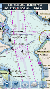
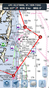
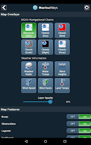
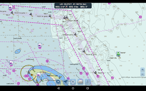
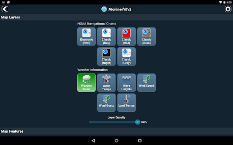
NAVIGATIONAL CHARTS
- United States charts provided by National Oceanic and Atmospheric Administration (NOAA)
- New Zealand charts provided by Land Information New Zealand (LINZ)
Chart types:
- NOAA Electronic Navigational Charts (ENC) (NOAA's newest and most powerful electronic charting product).
- NOAA classic charts (including Day, Red, Dusk, Night, and Gray versions).
- LINZ charts (available in Day, Dusk, and Night versions only currently)
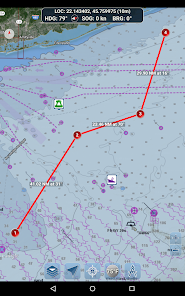
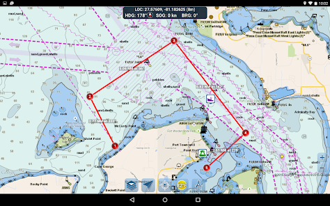
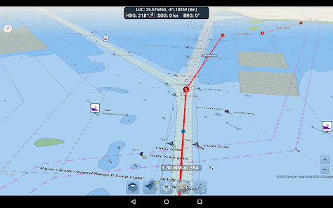
ROUTE PLANNING TOOLS
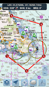
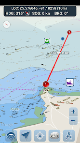
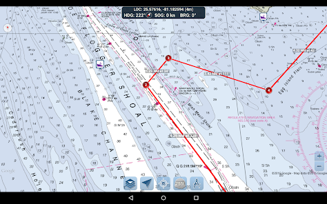
-Route Plotting. Tap and hold on the map for one second to plot your waypoints. To form a route, continue to tap and hold on the map in different areas. Distance and bearing are conveniently calculated and displayed for each leg as you add, adjust, or remove waypoints.
-Travel Mode. Automatically centers the map on your current position as you move. Use travel mode to see how closely you are following your plotted route in real time!
-Route Leg Summary. A convenient view containing detailed information of each leg you have plotted, including start and end coordinates, distance, and bearing.
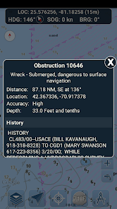
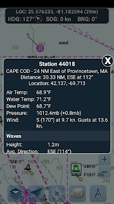
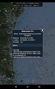
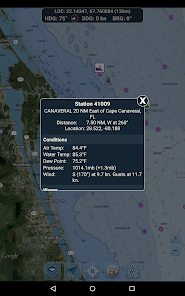
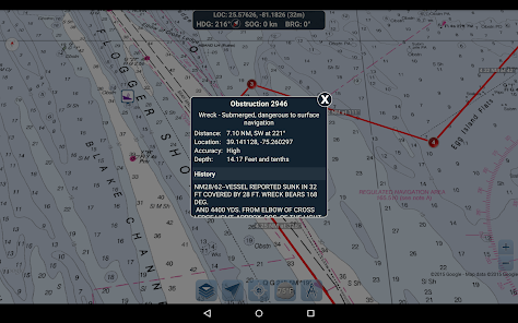
BUOY REPORTS AND OBSTRUCTION INFORMATION
Markers for buoys and obstructions are conveniently plotted in their actual location on the map! Just click on the marker to view their information!
- Buoy Reports: Get complete current conditions and wave reports for fixed and drifting buoys.
- Obstructions: Get location and history information about potentially dangerous, submerged hazards including rocks and sunken vessels.
NAVIGATION DASHBOARD
The navigational dashboard shows various real-time information including:
- Current location (latitude and longitude, with accuracy range)
- Current Heading (includes a small directional compass as well!)
- Current Speed Over Ground
- Current Bearing
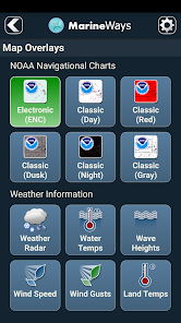
MARINE MAP OVERLAYS
Toggle various marine overlay data right onto the map to get a better idea of the current boating conditions!
Overlays include:
- Water Surface Temperature (Global)
- Wind Speeds (US only)
- Wind Gusts (US only)
- Wave Heights (US only)
LOCATION SHARING OVER WATER / VIEW OTHER BOATS
- Display your last known location, speed, bearing, and boat name on the map for other Marine Ways boaters to view.
- View the last known location, speed, bearing, and boat name of other Marine Ways boaters, as well as their distance and bearing from your location.
- Location sharing is turned off by default. When you are ready to share, toggle it on within general settings. To continuously update your location on the map, keep the app opened and focused. The app currently does not update your location in the background.
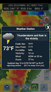
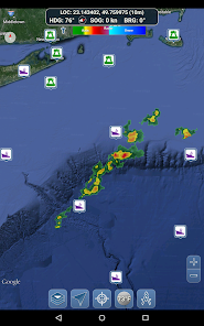
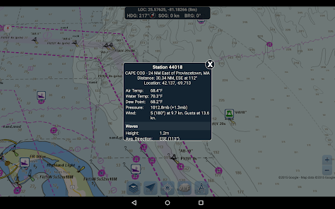
WEATHER INFORMATION
- Weather Precipitation Radar (US & Hawaii only). Detects any rain and snow in the area.
- Weather Station. Reports the nearest observation station data. Current temperature, humidity, weather conditions, wind, and more! Station observation data is available globally.
- Weather Alerts. Weather station also reports any active weather alerts issued by the National Weather Service such as severe thunderstorm warnings or hurricane warnings. Weather alert information is available for US, Alaska and Hawaii.
- Land Surface Temperature overlay. Shows the current surface temperature on land (US only).
Before using this application, please read and agree to the following terms of use / service and privacy policy:
Terms of Use / Service: http://www.marineways.com/appterms
Privacy policy: http://www.marineways.com/appprivacy
Navigational Charts Disclaimer from NOAA:
NOAA ENC Online is not certified for navigation. Screen captures of the ENCs displayed here do NOT fulfill chart carriage requirements for regulated commercial vessels under Titles 33 and 46 of the Code of Federal Regulations.
Enjoy the app! Marine Ways is also available on the web at http://www.marineways.com
NAVIGATIONAL CHARTS
- United States charts provided by National Oceanic and Atmospheric Administration (NOAA)
- New Zealand charts provided by Land Information New Zealand (LINZ)
Chart types:
- NOAA Electronic Navigational Charts (ENC) (NOAA's newest and most powerful electronic charting product).
- NOAA classic charts (including Day, Red, Dusk, Night, and Gray versions).
- LINZ charts (available in Day, Dusk, and Night versions only currently)
ROUTE PLANNING TOOLS
-Route Plotting. Tap and hold on the map for one second to plot your waypoints. To form a route, continue to tap and hold on the map in different areas. Distance and bearing are conveniently calculated and displayed for each leg as you add, adjust, or remove waypoints.
-Travel Mode. Automatically centers the map on your current position as you move. Use travel mode to see how closely you are following your plotted route in real time!
-Route Leg Summary. A convenient view containing detailed information of each leg you have plotted, including start and end coordinates, distance, and bearing.
BUOY REPORTS AND OBSTRUCTION INFORMATION
Markers for buoys and obstructions are conveniently plotted in their actual location on the map! Just click on the marker to view their information!
- Buoy Reports: Get complete current conditions and wave reports for fixed and drifting buoys.
- Obstructions: Get location and history information about potentially dangerous, submerged hazards including rocks and sunken vessels.
NAVIGATION DASHBOARD
The navigational dashboard shows various real-time information including:
- Current location (latitude and longitude, with accuracy range)
- Current Heading (includes a small directional compass as well!)
- Current Speed Over Ground
- Current Bearing
MARINE MAP OVERLAYS
Toggle various marine overlay data right onto the map to get a better idea of the current boating conditions!
Overlays include:
- Water Surface Temperature (Global)
- Wind Speeds (US only)
- Wind Gusts (US only)
- Wave Heights (US only)
LOCATION SHARING OVER WATER / VIEW OTHER BOATS
- Display your last known location, speed, bearing, and boat name on the map for other Marine Ways boaters to view.
- View the last known location, speed, bearing, and boat name of other Marine Ways boaters, as well as their distance and bearing from your location.
- Location sharing is turned off by default. When you are ready to share, toggle it on within general settings. To continuously update your location on the map, keep the app opened and focused. The app currently does not update your location in the background.
WEATHER INFORMATION
- Weather Precipitation Radar (US & Hawaii only). Detects any rain and snow in the area.
- Weather Station. Reports the nearest observation station data. Current temperature, humidity, weather conditions, wind, and more! Station observation data is available globally.
- Weather Alerts. Weather station also reports any active weather alerts issued by the National Weather Service such as severe thunderstorm warnings or hurricane warnings. Weather alert information is available for US, Alaska and Hawaii.
- Land Surface Temperature overlay. Shows the current surface temperature on land (US only).
Before using this application, please read and agree to the following terms of use / service and privacy policy:
Terms of Use / Service: http://www.marineways.com/appterms
Privacy policy: http://www.marineways.com/appprivacy
Navigational Charts Disclaimer from NOAA:
NOAA ENC Online is not certified for navigation. Screen captures of the ENCs displayed here do NOT fulfill chart carriage requirements for regulated commercial vessels under Titles 33 and 46 of the Code of Federal Regulations.
Enjoy the app! Marine Ways is also available on the web at http://www.marineways.com
Updated on
Safety starts with understanding how developers collect and share your data. Data privacy and security practices may vary based on your use, region, and age. The developer provided this information and may update it over time.

No data shared with third parties
Learn more about how developers declare sharing

This app may collect these data types
Location

Data is encrypted in transit

Data can’t be deleted
Ratings and reviews
4.5
1.89K reviews

A Google user
- Flag inappropriate
May 26, 2019
The program seems nice. The weather overlay takes a while to load on my phone, but it works well. I do not see that I am able to load maps offline, so at this point, I would not be able to trust it for use at sea. Also, I do not see anywhere to bookmark locations. It's a great start for a navigation program if those two features could be developed.
27 people found this review helpful

Jon Doe
- Flag inappropriate
December 31, 2020
This app saved my butt!! I was trying to make it into a narrow channel late at night with no moon. Couldn't see any land. The app helped me find channel bouys and the gps told me exactly where I was in relation to everything. The heading and speed information is also very helpful. I seem to remember it having a waypoint function but I haven't figured out how to make it dynamically change based on where exactly I am. It may not be a feature and it would be nice
82 people found this review helpful

Robert Denoncour
- Flag inappropriate
August 28, 2022
Very stable app.....no bugs that I could find. In the olden days all we had was a number of NOAA charts, a compass, parallel rules, dividers, and pelorus. Boat speed was trial and timing based on RPMs of engine. Oh, binoculars and a depth sounder completed the tool box. Seems life is easier today, but maybe less challenging. In any case take some boating classes from power squadron or coast guard auxiliary.
10 people found this review helpful
What's new
Misc adjustments and enhancements.
App support
phone
Phone number
+13072409520


