Valle d'Itria by bike
5+
Downloads

Everyone
info


About this app
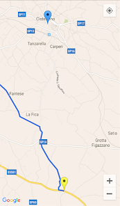
In Apulia, between the Ionian and Adriatic coasts rises the great limestone plateau of the Murgia where lies the idyllic Valle d'Itria among Locorotondo, Cisternino, Ceglie Messapica e Martina Franca. The rolling green valley is criss-crossed by dry-stone buildings and walls, vineyards, almond and olive groves, and winding country lanes which can be ridden by bike. Valle d'Itria, between Cisternino and Ceglie Messsapica, is crossed by "Water Bike Path" (Ciclovia dell'acqua, blue on the map) which was created upon the principal channel of the Apulian Aqueduct for about 11 km. From here a bike way of the Aqueduct starts and it is more than 250 km long.
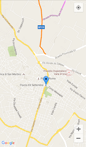
"Itria by bike" is not a touristic guide, but a way to ride with the tourist around Valle d'Itria to enjoy its beauty. The map indicates five different bike paths; therefore arm yourself with "Itria by bike", turn your GPS on and enjoy!
"Itria by bike" is not a touristic guide, but a way to ride with the tourist around Valle d'Itria to enjoy its beauty. The map indicates five different bike paths; therefore arm yourself with "Itria by bike", turn your GPS on and enjoy!
Updated on
Safety starts with understanding how developers collect and share your data. Data privacy and security practices may vary based on your use, region, and age. The developer provided this information and may update it over time.

No data shared with third parties
Learn more about how developers declare sharing

No data collected
Learn more about how developers declare collection


