
Drone Maps Japan
Contains ads
4.8star
5 reviews
5K+
Downloads

Rated for 3+
info
About this app
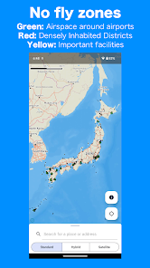
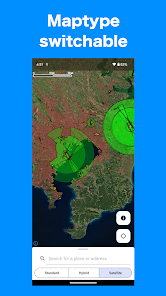
• Prohibited Airspace for Flight
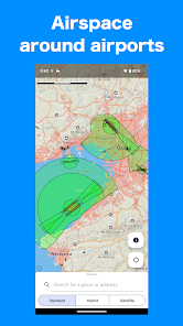
Green areas: Airspace around airports
Red areas: Densely Inhabited Districts (DID)
Yellow areas (black frame line): Important facilities
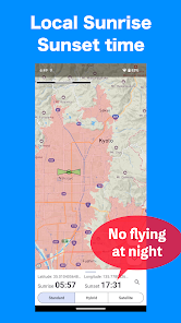
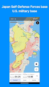
• Sunrise, sunset times
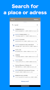
• Location, address search
• about 'Civil Aeronautics Act' in Japan
* Please be sure to check before flight:
Even if it is outside the prohibited area by civil aeronautics act, flying may be prohibited by the local government ordinance or land owner's rule.
Japan’s safety rules on Unmanned Aircraft (UA)/Drone
[Definition]
The term “UA/Drone” means any airplane, rotorcraft, glider or airship which cannot accommodate any person on board and can be remotely or automatically piloted. (Excluding those lighter than 100g. The weight of a UA/Drone includes that of its battery.)
[Prohibited Airspace for Flight]
Any person who intends to operate a UA/Drone in the following airspaces is required to obtain permission from the Minister of Land, Infrastructure, Transport and Tourism.
(A) Airspace above 150m above ground level.
(B) Airspace around airports. (airspaces above approach surface, horizontal surface, transitional surface, extended approach surface, conical surface and outer horizontal surface.)
(C) Above Densely Inhabited Districts (DID), which are defined and published by the Ministry of Internal Affairs and Communications.
*In this application, you can check the areas (B) and (C).
[Operational Limitations]
Any person who intends to operate a UA/Drone is required to follow the operational conditions listed below, unless approved by the Minister of Land, Infrastructure, Transport and Tourism.
1. Do not operate UAs/Drone under the influence of alcohol and drugs.
2. Operation of UAs/Drone after Preflight actions.
3. Operation of UAs/Drone to prevent of collision hazard with airplane and other UAs/Drone.
4. Do not opaerate UAs/Drone in a careless or reckless manner.
5. Operation of UAs/Drone in the daytime.
6. Operation of UAs/Drone within Visual Line of Sight (VLOS).
7. Maintenance of 30m operating distance between UAs/Drone and persons or properties on the ground/ water surface.
8. Do not operate UAs/Drone over event sites where many people gather.
9. Do not transport hazardous materials such as explosives by UA/Drone.
10. Do not drop any objects from UAs/Drone.
[Exception]
Requirements stated in “Airspace in which Flights are Prohibited” and “Operational Limitations” are not applied to flights for search and rescue operations by public organizations in case of accidents and disasters. (Except for a part of rules.)
[Penalty]
If the above rules are violated, the UAV operator is liable for a fine of up to 500,000 yen. (* If the 1. is violated, the UAV operator is liable for an inprisonment for up to one year or a fine of up to 300,000yen.)
[Permission & Approval]
You are required to submit an application in Japanese for the permission or approval to the Ministry of Land Infrastructure, Transport and Tourism at least 10 days (excluding Saturdays, Sundays, and holidays) before you fly a UA/Drone. For further information, please contact UA/Drone Counseling Service.(http://www.mlit.go.jp/common/001112966.pdf)
See link for details
https://www.mlit.go.jp/en/koku/uas.html
Law prohibiting the flying of small UAV
See link for details "Untranslated"
https://www.npa.go.jp/bureau/security/kogatamujinki/index.html
Green areas: Airspace around airports
Red areas: Densely Inhabited Districts (DID)
Yellow areas (black frame line): Important facilities
• Sunrise, sunset times
• Location, address search
• about 'Civil Aeronautics Act' in Japan
* Please be sure to check before flight:
Even if it is outside the prohibited area by civil aeronautics act, flying may be prohibited by the local government ordinance or land owner's rule.
Japan’s safety rules on Unmanned Aircraft (UA)/Drone
[Definition]
The term “UA/Drone” means any airplane, rotorcraft, glider or airship which cannot accommodate any person on board and can be remotely or automatically piloted. (Excluding those lighter than 100g. The weight of a UA/Drone includes that of its battery.)
[Prohibited Airspace for Flight]
Any person who intends to operate a UA/Drone in the following airspaces is required to obtain permission from the Minister of Land, Infrastructure, Transport and Tourism.
(A) Airspace above 150m above ground level.
(B) Airspace around airports. (airspaces above approach surface, horizontal surface, transitional surface, extended approach surface, conical surface and outer horizontal surface.)
(C) Above Densely Inhabited Districts (DID), which are defined and published by the Ministry of Internal Affairs and Communications.
*In this application, you can check the areas (B) and (C).
[Operational Limitations]
Any person who intends to operate a UA/Drone is required to follow the operational conditions listed below, unless approved by the Minister of Land, Infrastructure, Transport and Tourism.
1. Do not operate UAs/Drone under the influence of alcohol and drugs.
2. Operation of UAs/Drone after Preflight actions.
3. Operation of UAs/Drone to prevent of collision hazard with airplane and other UAs/Drone.
4. Do not opaerate UAs/Drone in a careless or reckless manner.
5. Operation of UAs/Drone in the daytime.
6. Operation of UAs/Drone within Visual Line of Sight (VLOS).
7. Maintenance of 30m operating distance between UAs/Drone and persons or properties on the ground/ water surface.
8. Do not operate UAs/Drone over event sites where many people gather.
9. Do not transport hazardous materials such as explosives by UA/Drone.
10. Do not drop any objects from UAs/Drone.
[Exception]
Requirements stated in “Airspace in which Flights are Prohibited” and “Operational Limitations” are not applied to flights for search and rescue operations by public organizations in case of accidents and disasters. (Except for a part of rules.)
[Penalty]
If the above rules are violated, the UAV operator is liable for a fine of up to 500,000 yen. (* If the 1. is violated, the UAV operator is liable for an inprisonment for up to one year or a fine of up to 300,000yen.)
[Permission & Approval]
You are required to submit an application in Japanese for the permission or approval to the Ministry of Land Infrastructure, Transport and Tourism at least 10 days (excluding Saturdays, Sundays, and holidays) before you fly a UA/Drone. For further information, please contact UA/Drone Counseling Service.(http://www.mlit.go.jp/common/001112966.pdf)
See link for details
https://www.mlit.go.jp/en/koku/uas.html
Law prohibiting the flying of small UAV
See link for details "Untranslated"
https://www.npa.go.jp/bureau/security/kogatamujinki/index.html
Updated on
Safety starts with understanding how developers collect and share your data. Data privacy and security practices may vary based on your use, region, and age. The developer provided this information and may update it over time.

This app may share these data types with third parties
App activity, App info and performance, and Device or other IDs

No data collected
Learn more about how developers declare collection

Data is encrypted in transit

Data can’t be deleted
Ratings and reviews
4.8
5 reviews
What's new
Adjusted display of latitude and longitude.