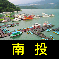
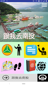
跟我去南投
Contains ads
50+
Downloads

Everyone
info
About this app
Nantou County is located in the central part of Taiwan, in the very center of the island. It is the only inland county in Taiwan. The area ranks second. Nantou City is the county seat, the largest city and the city with the highest population density and transportation center. The aborigines in the county include Atayal, Saidiq, Bunun, Tsou and Thao who live on the banks of Sun Moon Lake. Yushan, the highest peak in Taiwan, Sun Moon Lake, the largest natural lake, the source of the longest river Zhuoshuixi, and the geographic center of Taiwan are all located in the county. Specialties include green plums, bananas, sugar cane, frozen top oolong tea, Shaoxing wine, bamboo art products, Nantou pottery, and flowers. It is worth a visit for Chinese or foreigners. Based on the government's open data platform, collect, collate, proofread and supplement, develop this self-directed tour APP for the quality travel experience and guide of visiting tourists, and provide more than 200 scenic spots in detail. Users are hoped to visit Afterwards, the harvest was full.
Function brief
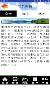
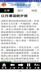
--Text explanation and operation
--Browsing function in photo album mode
--Photo with text description
--Voice commentary
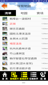
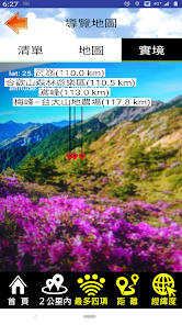
--Attraction list and reality guidance function (Location VR)
--Sorting of attraction name and distance
--Users can note key items
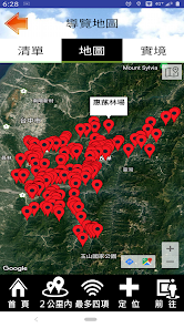
--Integrate Google Map to display location and navigation
--The map can switch between standard and satellite modes
--720 live viewing, can be used with Cardboard VR navigation device (part of the content)
--Practical digital audio guide function
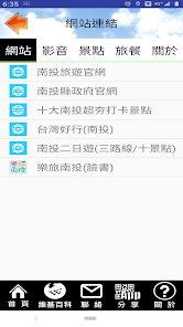
-Related blogs, websites, and video links that can be sorted and sorted
--Overall setting of interface font size
--Font size adjustment during text browsing (corresponding to the overall font setting)
--According to the user's mobile phone language settings, give the appropriate interface language
--Add function keys for frequently used URLs
Permission description
--Background location permission: This application will access the current location, which is only used to prompt nearby locations for navigation, display the current location and the relative location of the scenic spot on the map, provide navigation, and support real-world azimuth and distance guidance. This will happen even if the app is closed or not in use. The result of access at this location will not be transmitted and used for other functions.
--Photo permission: This application will download photos and data for offline use, reducing cloud traffic, and at the same time, reading data from the mobile phone makes navigation smoother.
--Camera permission: This application provides AR positioning function to guide various scenic spots through the lens.
Function brief
--Text explanation and operation
--Browsing function in photo album mode
--Photo with text description
--Voice commentary
--Attraction list and reality guidance function (Location VR)
--Sorting of attraction name and distance
--Users can note key items
--Integrate Google Map to display location and navigation
--The map can switch between standard and satellite modes
--720 live viewing, can be used with Cardboard VR navigation device (part of the content)
--Practical digital audio guide function
-Related blogs, websites, and video links that can be sorted and sorted
--Overall setting of interface font size
--Font size adjustment during text browsing (corresponding to the overall font setting)
--According to the user's mobile phone language settings, give the appropriate interface language
--Add function keys for frequently used URLs
Permission description
--Background location permission: This application will access the current location, which is only used to prompt nearby locations for navigation, display the current location and the relative location of the scenic spot on the map, provide navigation, and support real-world azimuth and distance guidance. This will happen even if the app is closed or not in use. The result of access at this location will not be transmitted and used for other functions.
--Photo permission: This application will download photos and data for offline use, reducing cloud traffic, and at the same time, reading data from the mobile phone makes navigation smoother.
--Camera permission: This application provides AR positioning function to guide various scenic spots through the lens.
Updated on
Safety starts with understanding how developers collect and share your data. Data privacy and security practices may vary based on your use, region, and age. The developer provided this information and may update it over time.

No data shared with third parties
Learn more about how developers declare sharing

No data collected
Learn more about how developers declare collection

Data is encrypted in transit

Data can’t be deleted
What's new
62 (2023.11.04)
-- 支援 Android 12、13 (API 33)
-- 預設地圖模式更改為衛星模式
-- 清單排序方式改為按編號、按標記、按距離。
-- 修正解安裝時的問題
-- 修復小部分錯誤
61 (20220427)
--更正名稱排序點選錯誤
60 (2021.10.08) 初版
--出版,支援正體中文
-- 支援 Android 12、13 (API 33)
-- 預設地圖模式更改為衛星模式
-- 清單排序方式改為按編號、按標記、按距離。
-- 修正解安裝時的問題
-- 修復小部分錯誤
61 (20220427)
--更正名稱排序點選錯誤
60 (2021.10.08) 初版
--出版,支援正體中文


