Note Cam Lite: GPS Camera
Contains adsIn-app purchases

4.5star
1.23K reviewsinfo
500K+
Downloads

PEGI 3
info


About this app
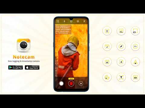
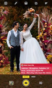
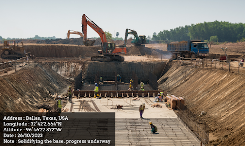
📝📸 The Note Cam Lite: GPS Camera is a note it timestamped map camera app that goes beyond capturing moments and allows you to add relevant notes to images and create a comprehensive visual narrative. Step into the world of enhanced storytelling and geolocation accuracy with this GPS memo camera and unleash your creativity like never before. 📝
📝📸 Distinct Features of the GPS Noteit Map Camera: 📝📸
💠 GPS location coordinates camera app tags your photos with gps coordinates to provide accurate location information
💠 Date-time stamp memo camera app creates meaningful & descriptive file names making it easier to organize and search for specific images
💠 GPS note timestamped location app provides an option to add detailed information and descriptions for your images
💠 GPS map camera date-time stamp app customize stamps with dates, time, locations, custom text or watermarks for additional information and branding
💠 Noteit GPS location coordinates app personalize the appearance of text with various font styles and colors to match it with your mood or theme
💠 GPS map camera location coordinates app with user friendly interface helps view, sort & organize photos easily based on date, location or custom tags
💠 Memo camera GPS coordinates app shares geotagged photos directly from the app or export them to be used in other applications or platforms
💠 GPS map camera location app offers an extensive solution for capturing, documenting & organizing photos with precise geolocation and customizable details
📝📸 The GPS Location Coordinates Camera is used to: 📝📸
💠 Capture geotagged photos during travels and outdoor adventures
💠 Document research findings and surveys with precise geolocation
💠 Capture property photos and add details for assessments
💠 Track routes and landmarks during outdoor activities
💠 Document, assess and manage construction projects
💠 Enhance personal memories with geotagged photos and remarks
💠 Document educational experiences and landmarks during field trips
💠 Utilize geotagged photos and notes for location-specific marketing
📝📸 With the ability to add descriptive notes to your images, the GPS map camera app not only lets you capture the visuals but also the thoughts, observations & emotions associated with your photos. Make your every photo tell a story with this noteit memo camera. 📝📸
📝📸 Get the The Note Cam Lite: GPS Camera now to capture moments with precision, add location stamps and detailed notes and preserve them as memories. 📝📸
Updated on
Safety starts with understanding how developers collect and share your data. Data privacy and security practices may vary based on your use, region, and age. The developer provided this information and may update it over time.

No data shared with third parties
Learn more about how developers declare sharing

No data collected
Learn more about how developers declare collection

Data is encrypted in transit

Data can’t be deleted
Ratings and reviews
4.5
1.22K reviews

Aaron P.
- Flag inappropriate
- Show review history
April 2, 2024
Love it. Would like it if they can make more updates as they go along. I don't like how the date and time are default in the file name and I can't remove it. I have been using this for work and it's amazing and quite useful. The date format can be expanded as well.
2 people found this review helpful

Zaharia Alexandru
- Flag inappropriate
March 14, 2021
I have just started using Notecam and I grow fond of it every day. I would love to have it connect to some weather forecast website and also add the info of temperature at the moment the photo is taken. I am currently using this app to document how tree buds develope during the flushing period and it would be easier for me to correlate these parameters, having them in the same photo: growth and temperature. Keep up the good work, I rated 5/5 stars obviously.
125 people found this review helpful

suresh pawar
- Flag inappropriate
September 24, 2021
This app is very good but ,the altitude shows wrong figures.So ,does it can be corrected?The example is that ,when I take a photo nearby the arebian see ,which is hardly about 6 km from my location,the altitude shows 72 meters.how it is correct ?,it's totally wrong one.Because ,the location is flat ground upto sea level.Anybody ,pl.clear my doubts
50 people found this review helpful


