
Sydney Bus
Contains ads
4.4star
71 reviews
5K+
Downloads

Rated for 3+
info
About this app
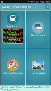
Provide timetable for Sydney transit (bus/ferry/tram/train)
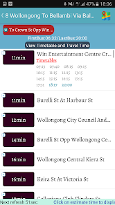
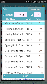
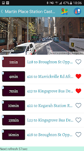
1. Nearby Stops
- Provid all nearby bus stops sorted by the distance from current location
- Click on a specific bus stop to display all bus routes via the stop
- Click on a specific route to further display all stop sequence and their estimated arrival times
- By clicking on a specific stop, you can further explore the stop nearby POI, such as food, restaurants, attractions and other store information.
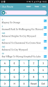
2. Bus Routes Information
- Searching specific bus information by using route#, stop#, or partial stop name
- Provide frequently used bus route for quickly selection.
3. Direction planning
- Provide the suggested traffic routes (walk, take bus, subway, train, etc.) between the desired departure and destination location
- Provide a well-planned route map to indicate the traffic types you need to use
- Use speech recognition to speed up the route planning
- Click on the destination to explore the nearby attractions around the destination, such as food, restaurants, attractions and other store information
- You can share the planned routes to a friend to his(her) LINE chat or EMAIL
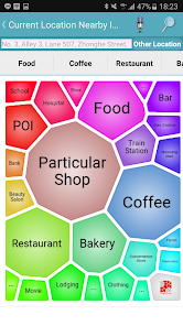
4. Nearby POI Search
- Provide nearby POI search
- The POI categories include snacks, coffee snacks, restaurants, MRT station, Bike point, train station, attractions, hospitals, supermarkets, beauty salons, hotels, clothing stores, bars, shoe stores, Shopping malls, schools, flower shops, electrical shops, banks, banks, travel agencies, bookstores, post offices, bicycle lines, steam locomotive, furniture, housing agents, pet shops, aquariums, etc.
- Use voice input to query specific stores such as McDonald's, Starbucks, ...
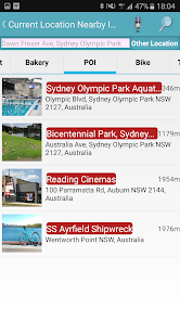
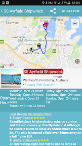
- Provide detailed information of a store, such as photos, rating score, address, URL,openning hours, comments, etc.
- Searching radius ranging from 500 meters to 7km can be set as your need
- Provide POI maps and street views. It also indicates the best route from current location (walking or cycling)
- Support search of cities or landmarks all over the world
- You can share POI information to a friend to his(her) LINE chat or EMAIL
1. Nearby Stops
- Provid all nearby bus stops sorted by the distance from current location
- Click on a specific bus stop to display all bus routes via the stop
- Click on a specific route to further display all stop sequence and their estimated arrival times
- By clicking on a specific stop, you can further explore the stop nearby POI, such as food, restaurants, attractions and other store information.
2. Bus Routes Information
- Searching specific bus information by using route#, stop#, or partial stop name
- Provide frequently used bus route for quickly selection.
3. Direction planning
- Provide the suggested traffic routes (walk, take bus, subway, train, etc.) between the desired departure and destination location
- Provide a well-planned route map to indicate the traffic types you need to use
- Use speech recognition to speed up the route planning
- Click on the destination to explore the nearby attractions around the destination, such as food, restaurants, attractions and other store information
- You can share the planned routes to a friend to his(her) LINE chat or EMAIL
4. Nearby POI Search
- Provide nearby POI search
- The POI categories include snacks, coffee snacks, restaurants, MRT station, Bike point, train station, attractions, hospitals, supermarkets, beauty salons, hotels, clothing stores, bars, shoe stores, Shopping malls, schools, flower shops, electrical shops, banks, banks, travel agencies, bookstores, post offices, bicycle lines, steam locomotive, furniture, housing agents, pet shops, aquariums, etc.
- Use voice input to query specific stores such as McDonald's, Starbucks, ...
- Provide detailed information of a store, such as photos, rating score, address, URL,openning hours, comments, etc.
- Searching radius ranging from 500 meters to 7km can be set as your need
- Provide POI maps and street views. It also indicates the best route from current location (walking or cycling)
- Support search of cities or landmarks all over the world
- You can share POI information to a friend to his(her) LINE chat or EMAIL
Updated on
Safety starts with understanding how developers collect and share your data. Data privacy and security practices may vary based on your use, region, and age. The developer provided this information and may update it over time.

No data shared with third parties
Learn more about how developers declare sharing

This app may collect these data types
App info and performance and Device or other IDs

Data is encrypted in transit

Data can’t be deleted
Ratings and reviews
4.4
69 reviews

Edwina May
- Flag inappropriate
March 26, 2024
Very useful app. Only fault doesn't show when buses gave been cut.

varaprasad tamminedi
- Flag inappropriate
June 13, 2023
Very nice app . would be nice to have alarm system so that if customer wants to set alarm 10 min early will help customers to catch the service with out missing. Also map with bus real time location
2 people found this review helpful

A Google user
- Flag inappropriate
- Show review history
October 18, 2019
I used this app for the first time today and I am very impressed. The amount of detail is exceptional and this is by far the best public transport app I have used. I'm especially pleased to have access to the timetable rather than only imminent arrivals and departures. Well done!
8 people found this review helpful
What's new
update route data


