
GPS Area Calculator For Land
Contains ads
100+
Downloads

Everyone
info


About this app
Land Area Calculator is good app for measuring distance and area. land area measurement on map measure distance free 2024. you can measure any place or location distance between two cities.
-> How does use?
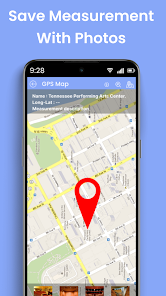
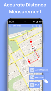
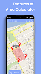
- Click on a map to create point then area measurement and distance for land on maps with latitude and longitude. area calculator for land the application will auto calculate distance and area then show information to maps. Select point with pivot you can easy search point you need to calculate area for land.
- Measure Area calculates the total area of all points you are pointed. Distance calculator map used to survey and calculate area for land on maps. We provide many functions to you can easy calculate exactly distance and area for land. Point all places which you want to calculate and measure 100% accurate area with units you can check it.
In gps field area measure, you can easily add and adjust markers on the map. And with GPS distance and land area calculator , you can record your current GPS position and measure area or distance on google map by simply moving around the location. This feature makes measuring distance and area easier and accurate without the need to manually specify your location.
GEO AREA is for:
- Land based surveys, for Farmers, for farm management, Land record management, Construction surveys, Agronomists, Town planners, Construction surveyor, Health, Education and facilities mapping, Farm fencing, Sports track measurement, Construction sites and building sites area, Asset mapping, Landscape artists Landscape design,land survey.
UNIQUE FEATURES for Land Distance Calculator :
- Easy to use drag and drop marker adjustment feature
- Fast area/distance marking
- Auto Walk feature
- Land measurement
- Area calculator for land by walking
- Accurate GPS land area and distance measurements
- Pin Point for very accurate pin placement
- Undo and delete option for all actions
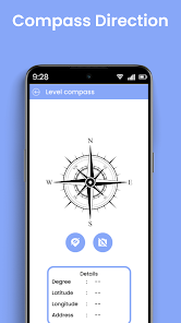
- Compass app
- GPS tracking/Auto measure for walking/driving around specific boundaries
- Land Sale
- GPS distance measurement for walking
- Effortless marker addition and deletion for manual measurements
- Land on Lease
- Note direction
- Compass features like Show True North, Magnetic strength, Show Altitude Speed, Show Sensor State
- Quick switching between gps fields area measurement modes
- Shopping feature of farming related products
- Straightforward Area & distance calculator km app
- Option to choose multiple maps for measurements
- Land Converter
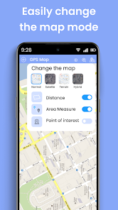
- Map tools Support map view with mode : Terrain map, hybrid map, normal map and satellite map.
- Supports multiple units of measurement (acre, meter, perimeter) for land area converter
Compass for android is great application that you can use it to find location, find direction in the dark night. We use maps to exactly your current location in the real-time.
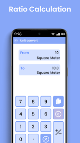
There is an inbuilt Unit Converter for measuring areas and distances in various Indian Land Units
-> How does use?
- Click on a map to create point then area measurement and distance for land on maps with latitude and longitude. area calculator for land the application will auto calculate distance and area then show information to maps. Select point with pivot you can easy search point you need to calculate area for land.
- Measure Area calculates the total area of all points you are pointed. Distance calculator map used to survey and calculate area for land on maps. We provide many functions to you can easy calculate exactly distance and area for land. Point all places which you want to calculate and measure 100% accurate area with units you can check it.
In gps field area measure, you can easily add and adjust markers on the map. And with GPS distance and land area calculator , you can record your current GPS position and measure area or distance on google map by simply moving around the location. This feature makes measuring distance and area easier and accurate without the need to manually specify your location.
GEO AREA is for:
- Land based surveys, for Farmers, for farm management, Land record management, Construction surveys, Agronomists, Town planners, Construction surveyor, Health, Education and facilities mapping, Farm fencing, Sports track measurement, Construction sites and building sites area, Asset mapping, Landscape artists Landscape design,land survey.
UNIQUE FEATURES for Land Distance Calculator :
- Easy to use drag and drop marker adjustment feature
- Fast area/distance marking
- Auto Walk feature
- Land measurement
- Area calculator for land by walking
- Accurate GPS land area and distance measurements
- Pin Point for very accurate pin placement
- Undo and delete option for all actions
- Compass app
- GPS tracking/Auto measure for walking/driving around specific boundaries
- Land Sale
- GPS distance measurement for walking
- Effortless marker addition and deletion for manual measurements
- Land on Lease
- Note direction
- Compass features like Show True North, Magnetic strength, Show Altitude Speed, Show Sensor State
- Quick switching between gps fields area measurement modes
- Shopping feature of farming related products
- Straightforward Area & distance calculator km app
- Option to choose multiple maps for measurements
- Land Converter
- Map tools Support map view with mode : Terrain map, hybrid map, normal map and satellite map.
- Supports multiple units of measurement (acre, meter, perimeter) for land area converter
Compass for android is great application that you can use it to find location, find direction in the dark night. We use maps to exactly your current location in the real-time.
There is an inbuilt Unit Converter for measuring areas and distances in various Indian Land Units
Updated on
Safety starts with understanding how developers collect and share your data. Data privacy and security practices may vary based on your use, region, and age. The developer provided this information and may update it over time.


What's new
bug fix


