
J天氣~追天氣(潮汐 天文 氣象觀測)
Contains ads
100+
Downloads

Rated for 3+
info
About this app
J Weather is a weather forecast app specially designed for outdoor enthusiasts. It uses map positioning and automatically queries the weather information on land, coast and offshore at the location.
Whether it is fishing, surfing, marine activities, mountain climbing, outings, photography, aerial photography, etc., J Weather can provide the most accurate and practical weather information.
J weather tool features:
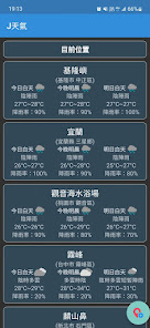
-Map positioning: You can use the map positioning function to quickly find the location you want to query, or let the App automatically locate the location.
-Multiple weather information:
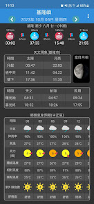
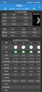
*Astronomical information*: View including moon phase diagram, sun and moon rise and set timetable, twilight timetable, etc.
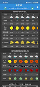
*Land weather information*: Check the land weather forecast for the current and next few days, including temperature, humidity, wind speed, wind direction, rainfall, air quality and other data. You can also check historical observations on land to understand actual weather conditions.
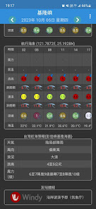
*Marine weather information*: You can view coastal and offshore weather forecasts, including wind power, wind direction, wave height, wave direction, wave speed, current speed and detailed tidal information. You can also check historical maritime observation data to understand the actual sea conditions.
*Visual weather factors*: Visualize weather factors, such as wind direction, wind force, wave height, wave direction and weather overview, etc., generate and display different icons, and quickly understand the weather overview through the icons.
- Freely select forecast stations and observation stations: If you want weather information that is more accurate and closer to your location, you can use this feature. You can adjust the weather forecast station location and observation location yourself and choose the most suitable site. This allows for more accurate and real-time weather information.
Whether it is fishing, surfing, marine activities, mountain climbing, outings, photography, aerial photography, etc., J Weather can provide the most accurate and practical weather information.
J weather tool features:
-Map positioning: You can use the map positioning function to quickly find the location you want to query, or let the App automatically locate the location.
-Multiple weather information:
*Astronomical information*: View including moon phase diagram, sun and moon rise and set timetable, twilight timetable, etc.
*Land weather information*: Check the land weather forecast for the current and next few days, including temperature, humidity, wind speed, wind direction, rainfall, air quality and other data. You can also check historical observations on land to understand actual weather conditions.
*Marine weather information*: You can view coastal and offshore weather forecasts, including wind power, wind direction, wave height, wave direction, wave speed, current speed and detailed tidal information. You can also check historical maritime observation data to understand the actual sea conditions.
*Visual weather factors*: Visualize weather factors, such as wind direction, wind force, wave height, wave direction and weather overview, etc., generate and display different icons, and quickly understand the weather overview through the icons.
- Freely select forecast stations and observation stations: If you want weather information that is more accurate and closer to your location, you can use this feature. You can adjust the weather forecast station location and observation location yourself and choose the most suitable site. This allows for more accurate and real-time weather information.
Updated on
Safety starts with understanding how developers collect and share your data. Data privacy and security practices may vary based on your use, region, and age. The developer provided this information and may update it over time.

No data shared with third parties
Learn more about how developers declare sharing

No data collected
Learn more about how developers declare collection

Data is encrypted in transit
What's new
修正歷史天氣資料顯示異常問題