

ATAK-CIV (Civil Use)

3.0star
1.06K reviews
100K+
Downloads

Teen
info


About this app
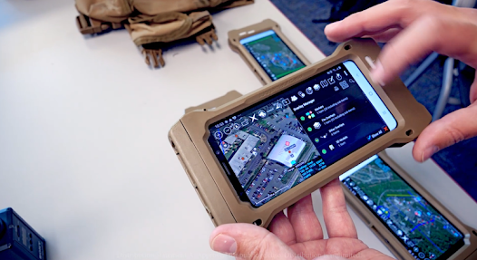
The Tactical Assault Kit is DoD nomenclature for the Team Awareness Kit (TAK) application: a mission planning, geospatial, Full Motion Video (FMV), and system administrator tool that reduces the operational footprint from a tactical laptop, to a commercial mobile device. The geospatial engine and communications component support Department of Defense (DoD) and commercial sector standards. Extensibility of the core platform is supported by the Software Development Kit (https://tak.gov), which enables any partner to develop mission-specific capability or contribute to the advancement of the baseline. Data can be pre-loaded into ATAK or downloaded from the network when available.
Civil use capabilities of ATAK-CIV include:
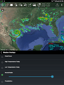
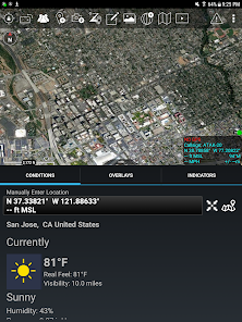
• Online and offline mapping (most standard formats), with a blazing fast rendering engine
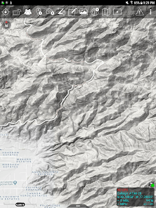
• Support for very high-resolution imagery (sub 1 cm resolution)
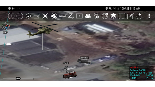
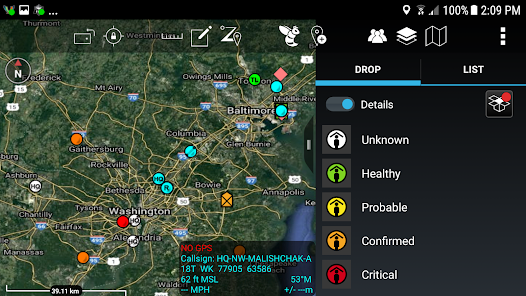
• Collaborative mapping, including points, drawings, locations of interest
• Extensive and customizable set of Icons
• Overlay Manager which allows the Import and display of KML, KMZ, GPX overlays, maps and imagery including both online and offline sources with adjustable transparency. These overlays can be treated as Gridded Refrence Gaphics.
• Location marking, sharing, history
• Chat, file sharing, photo sharing, video sharing, streaming
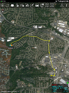
• Navigation-walking/hiking, driving, also useful flying and air-ground coordination
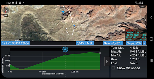
• Elevation Tools, heat maps, computed contour maps, viewsheds, routes w/DTED, SRTM, including dynamic profiling
• Hashtags and Sticky tags
• Center on Self, Center on other objects (e.g. another person in the network)
• Range, bearing, and other measurement tools
• Network-aware geofences with triggers
• "Bloodhound" destination tracking, including on moving objects
• Team Emergency Beacons
• Customizable Toolbar
• Radio controls and Integration
• Photo to map capability (aka Rubber Sheeting)
• Casualty evacuation tool
• Icon support for a wide variety of First Responder missions with further extensible Icons
• 3D perspective and ability to display 3D geospatial models
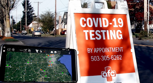
• Useful for First Responders, Hunting, fishing, ornithology, wildlife site survey
• ATAK-CIV is open source: https://github.com/deptofdefense/AndroidTacticalAssaultKit-CIV
System Requirements
Operating System: ATAK requires Android 5.0 (API 21) or later.
Hardware: ATAK does not require specific hardware and should run on any Android device that supports the other System Requirements.
Graphics: ATAK requires a graphics processor that supports GLES 3.0.
Storage, Memory and Processor: no specific requirements for storage, memory or processor- performance of the application will depend on the configuration.
Recommended for optimal experience: Samsung S9 equivalent hardware or newer is used and for a tablet style device Samsung S2 equivalent or newer.
TAK CORE
TAK CORE includes functionality that is common to all TAK applications and focuses on capabilities that can live in a cross-platform layer (simplifying the development and management of the library).
TAK CORE Features:
Networking – All ATAK applications use a variety of network mediums to send situational awareness data, chat messages, and other file types associated with mission planning activities. The networking component of TAK CORE handles creating the appropriate message at the application level (Cursor-on-Target), manages receiving and dispatching messages, and brokers communication with the TAK Server product.
Geospatial Data Processing – The TAK applications ingest geospatial imagery and overlay products for use on the moving map display.
Geospatial Data Visualization – A set of rendering utility and helper functions exist in TAK CORE to standardize the way geospatial imagery and overlays are rendered to the screen.
Geospatial Data Management – A data management capability is included in the TAK CORE to ensure that the data managed by TAK is relevant and accurate for the end user.
Civil use capabilities of ATAK-CIV include:
• Online and offline mapping (most standard formats), with a blazing fast rendering engine
• Support for very high-resolution imagery (sub 1 cm resolution)
• Collaborative mapping, including points, drawings, locations of interest
• Extensive and customizable set of Icons
• Overlay Manager which allows the Import and display of KML, KMZ, GPX overlays, maps and imagery including both online and offline sources with adjustable transparency. These overlays can be treated as Gridded Refrence Gaphics.
• Location marking, sharing, history
• Chat, file sharing, photo sharing, video sharing, streaming
• Navigation-walking/hiking, driving, also useful flying and air-ground coordination
• Elevation Tools, heat maps, computed contour maps, viewsheds, routes w/DTED, SRTM, including dynamic profiling
• Hashtags and Sticky tags
• Center on Self, Center on other objects (e.g. another person in the network)
• Range, bearing, and other measurement tools
• Network-aware geofences with triggers
• "Bloodhound" destination tracking, including on moving objects
• Team Emergency Beacons
• Customizable Toolbar
• Radio controls and Integration
• Photo to map capability (aka Rubber Sheeting)
• Casualty evacuation tool
• Icon support for a wide variety of First Responder missions with further extensible Icons
• 3D perspective and ability to display 3D geospatial models
• Useful for First Responders, Hunting, fishing, ornithology, wildlife site survey
• ATAK-CIV is open source: https://github.com/deptofdefense/AndroidTacticalAssaultKit-CIV
System Requirements
Operating System: ATAK requires Android 5.0 (API 21) or later.
Hardware: ATAK does not require specific hardware and should run on any Android device that supports the other System Requirements.
Graphics: ATAK requires a graphics processor that supports GLES 3.0.
Storage, Memory and Processor: no specific requirements for storage, memory or processor- performance of the application will depend on the configuration.
Recommended for optimal experience: Samsung S9 equivalent hardware or newer is used and for a tablet style device Samsung S2 equivalent or newer.
TAK CORE
TAK CORE includes functionality that is common to all TAK applications and focuses on capabilities that can live in a cross-platform layer (simplifying the development and management of the library).
TAK CORE Features:
Networking – All ATAK applications use a variety of network mediums to send situational awareness data, chat messages, and other file types associated with mission planning activities. The networking component of TAK CORE handles creating the appropriate message at the application level (Cursor-on-Target), manages receiving and dispatching messages, and brokers communication with the TAK Server product.
Geospatial Data Processing – The TAK applications ingest geospatial imagery and overlay products for use on the moving map display.
Geospatial Data Visualization – A set of rendering utility and helper functions exist in TAK CORE to standardize the way geospatial imagery and overlays are rendered to the screen.
Geospatial Data Management – A data management capability is included in the TAK CORE to ensure that the data managed by TAK is relevant and accurate for the end user.
Updated on
Safety starts with understanding how developers collect and share your data. Data privacy and security practices may vary based on your use, region, and age. The developer provided this information and may update it over time.

No data shared with third parties
Learn more about how developers declare sharing

No data collected
Learn more about how developers declare collection
Ratings and reviews
3.0
1.02K reviews

Dallas C
- Flag inappropriate
September 2, 2021
An excellent tool for coordinating public safety agencies during planned events or emergencies. You have to do some work to tap the full potential of the product. For example, gathering links for better maps or importing Digital Terrain Elevation Data. However, once you do, it's gold. Fair warning, though... it will crush your battery. Be prepared.
48 people found this review helpful
TAK Product Center
September 18, 2021
Thank you for your kind words. We strive in each release to continue improve batter life.

Wes Coleman
- Flag inappropriate
September 4, 2020
The learning curve for this software is much steeper than your typical "mobile app". You'll need to read the manual and train your team in how to use it. It takes a bit of work to get maps and elevation data imported. Once that's done the app's functionality in geospatial awareness is very deep and can be made to work offline. You'll have to run your own server to get the most out of the "Team Awareness" features of this software if your office doesn't already have one set up. It's not exactly turn-key in terms of ease of use, but ATAK can be a game changer for work and play with the right infrastructure. I mostly use it for measuring distances and altitudes on a map and keeping track of my team when out biking, so I'm only scratching the surface of ATAK's functionality.
79 people found this review helpful

Chris C
- Flag inappropriate
April 28, 2022
This app is a huge security/opsec risk. App won't run without giving it full access to camera, microphone, gps location, management of all files and storage access, ALL THE TIME. Cannot set permissions to "Only while using the app." This allows for an unknown remote entity to have full control over your device at any time, even when not using the app. No thanks - deleted.
201 people found this review helpful
TAK Product Center
June 6, 2022
We are working on only requesting audio/camera/microphone permissions when the user actually goes into those workflows in the future. Unlike other android apps, our quit button is legit and the application does not continue running in the background. Additionally, we do not collect any data.


