
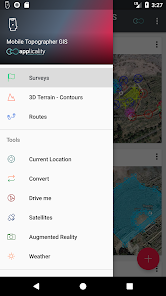
Mobile Topographer GIS
In-app purchases
3.3star
1.49K reviews
100K+
Downloads

Everyone
info
About this app
The beloved choice of the professionals, Mobile Topographer ...meets... GIS.
You can now perform a complete survey without any limitations into complexity or volume of data.
Try now Mobile Topographer GIS by using the three days free trial period. Just download the app and proceed with he subscription procedure. Although, you will be asked to provide billing information, you will NOT be charged before the end of the three days of the free trial period. You can cancel your subscription at any time during the three days trial period, free of charge. Charges will only occur, if at the end of the three days you still have an active subscription.
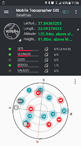
- Collect GNSS readings using increased accuracy (GPS, GLONASS, Galileo, Beidou, QZSS constellations supported).
- Connect your external GNSS receiver via mock locations and use Mobile Topogrpaher GIS as a processing unit.
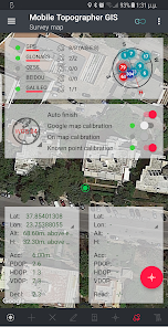
- Display data into WGS84 or you local projected CRS.
- Convert from WGS84 to local projected CRS and vice versa.
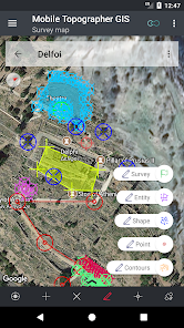
- Real time projection on map.
- *** NEW *** Custom image or WMS server as map background.
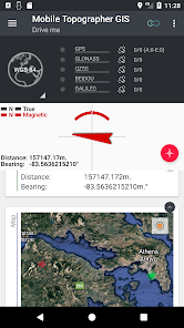
- Find a marked point in the real world by using "Drive me"
- Calculate Orthometric height on the fly using EGM model or local elevation grids where available.
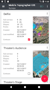
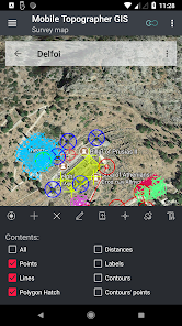
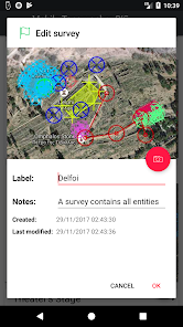
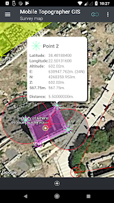
- Organize your work into Points - Shapes - Entities & Surveys. You can now create individual points, multi-point groups, multipart polylines, and multipart polygons with holes.
- Create a full drawing with as much details as you want.
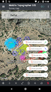
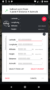
- *** NEW *** geodetic tools. Add indirect points via on of the following options: 1 point + Distance + Azimuth, 2 points + Distances + Select, 2 points + Azimuths, 3 points + Distances, Midpoint of line, Divide line, Extend line, Parallel line, Perpendicular to line.
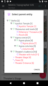
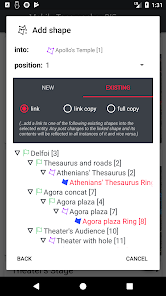
- Nest your jobs, in any nesting level, to create a super-survey.
- Share data between jobs with active links.
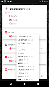
- Exchange jobs between your mobile device and your desktop computer, with import - export functions using all common formats .txt, .csv, .kml, .gpx, .dxf and Shape files (.shp - .shx - .dbf)
- Collaborate with your partners by exchanging and sharing from one point to complete jobs.
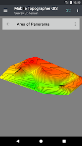
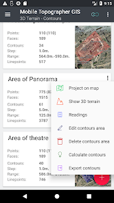
- Create the 3D terrain of an area by simply walking through it.
- Calculate contours and add them into your survey with lightning speeds.
- View a real 3D model directly into your device.
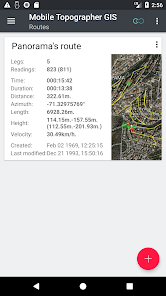
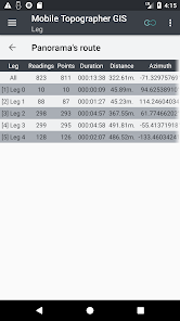
- Store a route with its data.
- Show GNSS satellites with signal info in both compass view or AR.
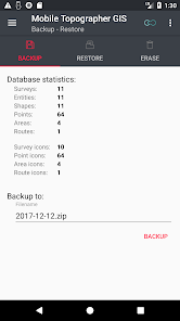
- Backup and restore your data using an SQL .db file.
Welcome to the era of mobile surveying...!
Find more about Mobile Topographer GIS in:
http://applicality.com/projects/mobile-topographer-gis/
Download the user's manual from:
http://applicality.com/app_documentation/web/MobileTopographerGIS_Manual.pdf
You can now perform a complete survey without any limitations into complexity or volume of data.
Try now Mobile Topographer GIS by using the three days free trial period. Just download the app and proceed with he subscription procedure. Although, you will be asked to provide billing information, you will NOT be charged before the end of the three days of the free trial period. You can cancel your subscription at any time during the three days trial period, free of charge. Charges will only occur, if at the end of the three days you still have an active subscription.
- Collect GNSS readings using increased accuracy (GPS, GLONASS, Galileo, Beidou, QZSS constellations supported).
- Connect your external GNSS receiver via mock locations and use Mobile Topogrpaher GIS as a processing unit.
- Display data into WGS84 or you local projected CRS.
- Convert from WGS84 to local projected CRS and vice versa.
- Real time projection on map.
- *** NEW *** Custom image or WMS server as map background.
- Find a marked point in the real world by using "Drive me"
- Calculate Orthometric height on the fly using EGM model or local elevation grids where available.
- Organize your work into Points - Shapes - Entities & Surveys. You can now create individual points, multi-point groups, multipart polylines, and multipart polygons with holes.
- Create a full drawing with as much details as you want.
- *** NEW *** geodetic tools. Add indirect points via on of the following options: 1 point + Distance + Azimuth, 2 points + Distances + Select, 2 points + Azimuths, 3 points + Distances, Midpoint of line, Divide line, Extend line, Parallel line, Perpendicular to line.
- Nest your jobs, in any nesting level, to create a super-survey.
- Share data between jobs with active links.
- Exchange jobs between your mobile device and your desktop computer, with import - export functions using all common formats .txt, .csv, .kml, .gpx, .dxf and Shape files (.shp - .shx - .dbf)
- Collaborate with your partners by exchanging and sharing from one point to complete jobs.
- Create the 3D terrain of an area by simply walking through it.
- Calculate contours and add them into your survey with lightning speeds.
- View a real 3D model directly into your device.
- Store a route with its data.
- Show GNSS satellites with signal info in both compass view or AR.
- Backup and restore your data using an SQL .db file.
Welcome to the era of mobile surveying...!
Find more about Mobile Topographer GIS in:
http://applicality.com/projects/mobile-topographer-gis/
Download the user's manual from:
http://applicality.com/app_documentation/web/MobileTopographerGIS_Manual.pdf
Updated on
Safety starts with understanding how developers collect and share your data. Data privacy and security practices may vary based on your use, region, and age. The developer provided this information and may update it over time.

No data shared with third parties
Learn more about how developers declare sharing

No data collected
Learn more about how developers declare collection
Ratings and reviews
3.3
1.46K reviews

Jared Beaudry
- Flag inappropriate
September 8, 2022
Interesting features, but at the end of the 3 day trial I was charged $17 before being required to pay $35 for the yearly subscription so I can continue using the app. I understand charging if I dont cancel my trial, that's normal, but it's a FREE trial (not $17) so if I'm being charged at the end of the trial I expect that to be my payment for the app. Also does not show up in your Google subscriptions so I'm not really sure how to approach this issue. Seems pretty scammy. You should fix this..
61 people found this review helpful

Okechukwu CrazeMan Umerika
- Flag inappropriate
August 20, 2023
It doesn't have the feature for choosing points remotely and off-site. For the fact that all the points must be choose chosen while at the site., AND FOR THE FACT THAT IT DOESN'T SHOW POINT-HEIGHTS,, I am not going to waste more time using this App.. I need Apps that would allow me to use it and work remotely, so far I know how to locate the place on a map.
24 people found this review helpful

Ogbuji Stanley
- Flag inappropriate
- Show review history
February 15, 2024
Atleast users should see the architecture and view of the app before demanding for subscription. I can't access this because of card decline by Google. But how can I get new card when I can see what I am subscribing for. Is really not a good users' experience. Please try and do something about this.
4 people found this review helpful
What's new
v.6.0.15 - More bug fixes.


