
Wavve Boating: Marine Boat GPS
In-app purchases

4.5star
1.29K reviews
100K+
Downloads

Everyone
info


About this app
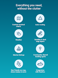
When it comes to marine navigation, nautical charts, and boating maps, The Wavve Boating App is an easy choice. Wavve Boating improved outdated marine navigation apps, tide charts, and depth finders by combining them into one tool. Stay updated on current boating conditions, like marine weather, wave heights, water depths, and tides without a weather app. Access sea maps for your boat, water depths, marine traffic, boat ramps, and other boating tools from the boat navigation app. Don’t waste money on pro chart plotters, depth finders, or Navionics. Boat, sail, ski, and fish with your android phone with the top rated marine GPS in the US, Australia, Canada, and UK.
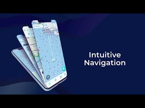
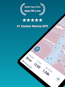
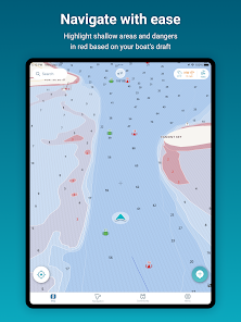
🧭 SEAMLESS MARINE NAVIGATION
Forget crowded nautical charts and confusing boat maps; with Wavve Boating GPS, it’s easy to get boat directions and view water depths the moment you leave the boat ramp. Plan to navigate out on a lake, river, sea, or ocean? Leverage offline planning to route your next trip. See why sailors and captains call us Google Maps for Boating!
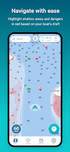
🗺️ CUSTOMIZED MARINE CHARTS
Wavve Boating customizes 15,000+ nautical charts based on your boat's draft. Our Marine App use chartplotter data specific to your vessel. Gone are the days of marine navigation with cluttered chart plotters and buying marine charts piece by piece like in Navionics Boating. Wavve has integrated marine charts into one map for all your boat GPS needs. Marine charts are available in the USA, Canada, Australia, and UK.
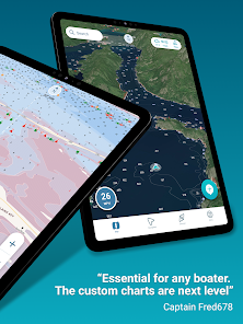
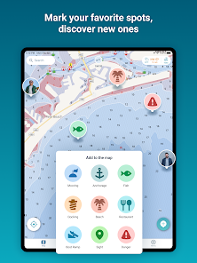
🚤 LARGEST BOATING COMMUNITY
Similar to Waze for boats, easily view other drivers on the map and add them as friends. Discover unique boating destinations only available on the water. Wave goodbye to other apps like Navionics, Savvy Navvy, and C-Map and see top rated fishing spots, boat ramps, marinas, moorings, fuel, beaches, islands, sandbars, restaurants, dock and dines, and more! Share insightful boating knowledge and marked points of interest with a community of boaters...or keep them private and hide your ship tracking at any time 🏴☠️
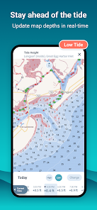
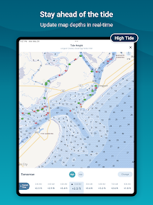
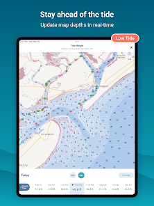
🌊 TIDES
Stay ahead of the tide and avoid shallow waters. The Wavve Boating map automatically adjusts to display current water levels based on tide charts and tidal changes near you. Quickly view hourly tide levels up to 3 days in advance. Wavve takes the stress out of high and low tide and helps fisherman planning when fish are most active.
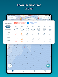
☀️ MARINE WEATHER 🌨
Avoid the storm with a marine weather tool that includes wind, rain, wave, tidal, and other weather charts to help you know sea conditions. View 7-day marine weather forecasts down to the hour, including weather conditions, temperature, wind speed, wind direction, currents, and wave heights. Boat weather forecasts don't need to be a mystery. Leverage the reach of NOAA forecasts and local boating weather sources in one easy to use app.
📍CHART COVERAGE
Current nautical chart data includes the United States, Australia, Canada, Great Lakes, Florida, 1000 Islands, St. Lawrence River, United Kingdom and Caribbean. Our marine gps app works with all botes including center consoles, pontoons, wake and ski boats. View our ocean chart coverage and river maps at https://wavveboating.com/map/.
🏷️ SUBSCRIPTION PRICING
Wavve is a free boat navigation app. Find your local boat launch with a full featured free trial. After the free trial, choose from monthly ($7.99/month) or yearly subscriptions ($45.99/year...a 50% savings!)
📖 MORE INFORMATION
Want a marine GPS app to replace your boat chart plotter or ocean depth finder? Love wavvemarine? We integrate with SeaDoo and BRP Go. Want an alternative to Navionics, Savvy Navvy, Argo, iNavX, Aqua Maps, BRP Go, C-Map, Dockwa, Simrad, BoatUS, Garmin Active Captain, or other boat apps? Better than savvynavvy, aquamaps, cmap, and bote. Visit: https://wavveboating.com.
TERMS: https://wavveboating.com/terms-of-service/
PRIVACY: https://wavveboating.com/privacy-policy/
🧭 SEAMLESS MARINE NAVIGATION
Forget crowded nautical charts and confusing boat maps; with Wavve Boating GPS, it’s easy to get boat directions and view water depths the moment you leave the boat ramp. Plan to navigate out on a lake, river, sea, or ocean? Leverage offline planning to route your next trip. See why sailors and captains call us Google Maps for Boating!
🗺️ CUSTOMIZED MARINE CHARTS
Wavve Boating customizes 15,000+ nautical charts based on your boat's draft. Our Marine App use chartplotter data specific to your vessel. Gone are the days of marine navigation with cluttered chart plotters and buying marine charts piece by piece like in Navionics Boating. Wavve has integrated marine charts into one map for all your boat GPS needs. Marine charts are available in the USA, Canada, Australia, and UK.
🚤 LARGEST BOATING COMMUNITY
Similar to Waze for boats, easily view other drivers on the map and add them as friends. Discover unique boating destinations only available on the water. Wave goodbye to other apps like Navionics, Savvy Navvy, and C-Map and see top rated fishing spots, boat ramps, marinas, moorings, fuel, beaches, islands, sandbars, restaurants, dock and dines, and more! Share insightful boating knowledge and marked points of interest with a community of boaters...or keep them private and hide your ship tracking at any time 🏴☠️
🌊 TIDES
Stay ahead of the tide and avoid shallow waters. The Wavve Boating map automatically adjusts to display current water levels based on tide charts and tidal changes near you. Quickly view hourly tide levels up to 3 days in advance. Wavve takes the stress out of high and low tide and helps fisherman planning when fish are most active.
☀️ MARINE WEATHER 🌨
Avoid the storm with a marine weather tool that includes wind, rain, wave, tidal, and other weather charts to help you know sea conditions. View 7-day marine weather forecasts down to the hour, including weather conditions, temperature, wind speed, wind direction, currents, and wave heights. Boat weather forecasts don't need to be a mystery. Leverage the reach of NOAA forecasts and local boating weather sources in one easy to use app.
📍CHART COVERAGE
Current nautical chart data includes the United States, Australia, Canada, Great Lakes, Florida, 1000 Islands, St. Lawrence River, United Kingdom and Caribbean. Our marine gps app works with all botes including center consoles, pontoons, wake and ski boats. View our ocean chart coverage and river maps at https://wavveboating.com/map/.
🏷️ SUBSCRIPTION PRICING
Wavve is a free boat navigation app. Find your local boat launch with a full featured free trial. After the free trial, choose from monthly ($7.99/month) or yearly subscriptions ($45.99/year...a 50% savings!)
📖 MORE INFORMATION
Want a marine GPS app to replace your boat chart plotter or ocean depth finder? Love wavvemarine? We integrate with SeaDoo and BRP Go. Want an alternative to Navionics, Savvy Navvy, Argo, iNavX, Aqua Maps, BRP Go, C-Map, Dockwa, Simrad, BoatUS, Garmin Active Captain, or other boat apps? Better than savvynavvy, aquamaps, cmap, and bote. Visit: https://wavveboating.com.
TERMS: https://wavveboating.com/terms-of-service/
PRIVACY: https://wavveboating.com/privacy-policy/
Updated on
Safety starts with understanding how developers collect and share your data. Data privacy and security practices may vary based on your use, region, and age. The developer provided this information and may update it over time.

No data shared with third parties
Learn more about how developers declare sharing

This app may collect these data types
Location, Personal info and 5 others

Data is encrypted in transit

You can request that data be deleted
Ratings and reviews
4.5
1.22K reviews

John McGlade
- Flag inappropriate
June 3, 2023
I'm new at boating. I spent $1000 dollars on a depth finder/ fish finder. 90% of the time it's useless. if I driving it' works sometimes and when I need it most it doesn't work. with that being said the wavve app saved me and made boating less stressful. It's never let me down and so simple to use . I feel so much more confident. I can't believe how accurate it is . I 100% rely on it and tell everyone I meet the benefits of wavve. I've had a couple of my friends try it out and we're sold .
69 people found this review helpful
Wavve Boating
June 16, 2023
Hi John, thanks so much for feedback and 5-star review! We really appreciate your feedback! Can we mail you a hat???Reach out to us at community@wavveboating.com anytime and we will set that up. Thanks again and have a wonderful summer boating!

Marko
- Flag inappropriate
August 24, 2021
Multiple times while on the Waccamaw River it would not show channels and outlets that Google maps would. Multiple times I would have to use Google maps to get back to my original location. This app does not have full mapping capabilities. Also, and this is minor, I've tried connecting with other people multiple times and not one connection. Maybe they are not receiving the request but I do not find this very community friendly as advertised.. Canceling my subscription.
57 people found this review helpful
Wavve Boating
August 25, 2021
Hi Okram, sorry to hear about this issue. Not all of the Waccamaw river is charted by NOAA. We'll work to improve this along with making it easier to build out your fleet in wavve - thank you for this feedback.

Chrystian Tyler
- Flag inappropriate
- Show review history
December 10, 2020
Any news on updating with a night version. It's really the only thing missing. Otherwise great app but impossible to use at night with such a bright background. Please just invert the whites to black and charcoal with a darker blue for water. That would be great, thank you Why is there no night mode? Still learning the app but I don't see a night mode or an actual way to navigate to a destination... Just shows where I am...... Still waiting on the night version
54 people found this review helpful
Wavve Boating
October 2, 2019
Hi Chrystian, thanks for your feedback. Night mode is in consideration for development this fall/winter and we will factor your input for prioritization. You can create a route to a given location by tapping the higher of the two teal buttons on the bottom right of the map screen. We are in mid development of further nav features. Thank you!
What's new
We’ve made further improvements to the routing and mapping experience. We’re always eager for your feedback. If you ever need a hand, please reach out at community@wavveboating.com.


