TwoTrails
4.2star
5 reviews
1K+
Downloads

Everyone
info
About this app
TwoTrails is a timber cruising and timber sales admin surveying package. It is maintained and developed by the Forest Management Service Center. Though it is specifically written for USDA forestry personal, it is freely available to anyone. Many of the program capabilities are shared below:
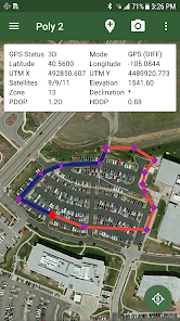
• Manages all surveying methods approved by USDA Forest Service Handbook, FSH 2409.12, Chapter 50, Area Determination.
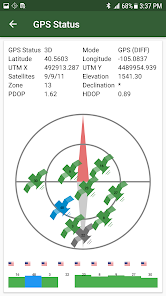
• Real-time GPS surveys:
• GPS Walk (Breadcrumb)
• GPS Angle Point (Take5)
• Real-time surveys:
• Direction Distance Traversing
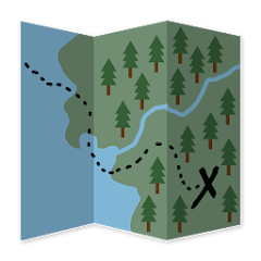
• Radial (example: Island Exclusions)
• Corridors (example: Hazard Tree)
• Combined use of multiple survey types:
• GPS surveys
• Digitized Information (Shape Files, KML/KMZ, GPX, CSV)
• Remote sensing information
• Create Grid (Sample) Point sand Navigate to them
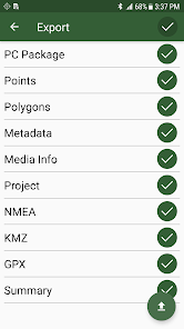
• Exports:
• KMZ and GPX
• Project Status and Information
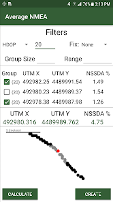
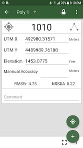
• CSV’s (Points, Polygons, Metadata, NMEA Information, etc..)
• Automatically calculates area-error for comparison with handbook standard
• Manages all surveying methods approved by USDA Forest Service Handbook, FSH 2409.12, Chapter 50, Area Determination.
• Real-time GPS surveys:
• GPS Walk (Breadcrumb)
• GPS Angle Point (Take5)
• Real-time surveys:
• Direction Distance Traversing
• Radial (example: Island Exclusions)
• Corridors (example: Hazard Tree)
• Combined use of multiple survey types:
• GPS surveys
• Digitized Information (Shape Files, KML/KMZ, GPX, CSV)
• Remote sensing information
• Create Grid (Sample) Point sand Navigate to them
• Exports:
• KMZ and GPX
• Project Status and Information
• CSV’s (Points, Polygons, Metadata, NMEA Information, etc..)
• Automatically calculates area-error for comparison with handbook standard
Updated on
Safety starts with understanding how developers collect and share your data. Data privacy and security practices may vary based on your use, region, and age. The developer provided this information and may update it over time.

No data shared with third parties
Learn more about how developers declare sharing

No data collected
Learn more about how developers declare collection
What's new
1.3.4
Android 13 compatibility updates
Updated NMEA parsing with delimiter based mode
Misc other bug fixes and optimizations
1.3.3
Import and Export Fixes
Fix for Geode3 Receiver
Legacy Support for Android 9 Devices
Misc other bug fixes and optimizations
1.3.2
New Sales Admin Tool
Android 12 compatibility updates
-Storage
-Bluetooth connections
-Permissions
UI Updates
Misc bug fixes


