
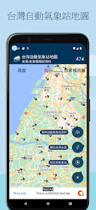
台灣自動氣象站地圖
Contains ads
100+
Downloads

Everyone
info

About this app
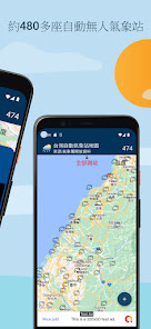
This application does not represent the government, political entities, agencies, organizations or their affiliated departments, and only uses their publicly available open information. The observation data map of unmanned automatic weather stations using released open data is updated every hour, and there are currently about 480 of them.
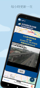
There are 5,000 real-time image data built-in. You can select real-time image lenses (up to 10) within seven kilometers of the selected survey station.
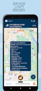
After clicking the weather station icon on the map, the station's altitude, temperature, humidity, air pressure, wind direction, wind speed, daily accumulated rainfall, today's highest temperature, northern lowest temperature, and today's maximum wind gust speed are provided.
Permission request:
Location permission (approximate location) to display automatic weather stations near your location.
Instructions for using device location data:
The [Location] permission needs to be enabled. "Taiwan Automatic Weather Station Map Application" will not collect location data after the application is closed or not in use.
source:
Open information made public by the public sector. The [Taiwan Automatic Weather Station Map] application does not represent the government, political entities, agencies, organizations or their affiliated departments, and only uses their public open data.
Disclaimer:
1. This data source is an open data set released by the public sector.
2. The [Taiwan Automatic Weather Station Map] application does not represent the government, political entities, agencies, organizations or their affiliated departments, and only uses their public open data.
3. [Taiwan Automatic Weather Station Map] application only uses these open data to provide users with reference, and is not responsible for the accuracy or availability of these open data.
4. The disclaimer will be displayed simultaneously in the store description, the application itself and the privacy policy
There are 5,000 real-time image data built-in. You can select real-time image lenses (up to 10) within seven kilometers of the selected survey station.
After clicking the weather station icon on the map, the station's altitude, temperature, humidity, air pressure, wind direction, wind speed, daily accumulated rainfall, today's highest temperature, northern lowest temperature, and today's maximum wind gust speed are provided.
Permission request:
Location permission (approximate location) to display automatic weather stations near your location.
Instructions for using device location data:
The [Location] permission needs to be enabled. "Taiwan Automatic Weather Station Map Application" will not collect location data after the application is closed or not in use.
source:
Open information made public by the public sector. The [Taiwan Automatic Weather Station Map] application does not represent the government, political entities, agencies, organizations or their affiliated departments, and only uses their public open data.
Disclaimer:
1. This data source is an open data set released by the public sector.
2. The [Taiwan Automatic Weather Station Map] application does not represent the government, political entities, agencies, organizations or their affiliated departments, and only uses their public open data.
3. [Taiwan Automatic Weather Station Map] application only uses these open data to provide users with reference, and is not responsible for the accuracy or availability of these open data.
4. The disclaimer will be displayed simultaneously in the store description, the application itself and the privacy policy
Updated on
Safety starts with understanding how developers collect and share your data. Data privacy and security practices may vary based on your use, region, and age. The developer provided this information and may update it over time.

No data shared with third parties
Learn more about how developers declare sharing

No data collected
Learn more about how developers declare collection

Data is encrypted in transit
What's new
Bug Fixes & Performance Improvements.
新增測站附近的即時影像(七公里若有的話)。
新增測站附近的即時影像(七公里若有的話)。


