
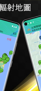
台灣環境輻射地圖
Contains ads
10+
Downloads

Everyone
info


About this app
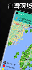
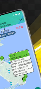
A national environmental radiation detection real-time information map using open data released by the public sector, totaling information on about 122 measuring stations. The measuring stations update the data every 5 minutes.
The weather of the measuring station is obtained by querying the open weather API of the GPS location and is for reference only.
Permission request:
Location (coarse location) to move the map to show ambient radiation observatories near your location.
Instructions for using device location data:
The [Location] permission needs to be enabled. "Taiwan Environmental Radiation Map" will not collect location data after the application is closed or not in use.
source:
Open data API released by the Nuclear Safety Council and Taiwan Electric Power Company.
Disclaimer:
1. This data source is an open data set released by [The Nuclear Safety Council and Taipower].
2. The [Taiwan Environmental Radiation Map] application does not represent the government, political entities, agencies, organizations or their affiliated departments, and only uses their publicly available open data.
3. The [Taiwan Environmental Radiation Map] application only uses these open data to provide users with reference, and is not responsible for the accuracy or availability of these open data.
4. The disclaimer will be displayed simultaneously in the store description, the application itself, and the privacy policy.
Updated on
Safety starts with understanding how developers collect and share your data. Data privacy and security practices may vary based on your use, region, and age. The developer provided this information and may update it over time.

No data shared with third parties
Learn more about how developers declare sharing

No data collected
Learn more about how developers declare collection

Data is encrypted in transit
What's new
Bug fixes and Performance Improvements.


