台灣道路狀況地圖
Contains ads
10+
Downloads

Rated for 3+
info
About this app
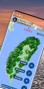
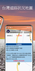
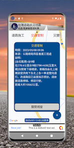
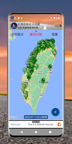
Approximately 1,000 reported events are displayed in the form of map icons, and classifications such as event sorting are provided. Users can click on the icon to view notification conditions and precautions on nearby roads.
Permission request:
Location permissions to display reference traffic conditions near the location of the device and provide a reference distance to the location of the event.
source:
Open datasets released by the public sector.
Disclaimer:
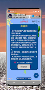
1. The data source is an open data set released by [Ministry of the Interior].
2. The [Taiwan Road Condition Map] application does not represent the government, political entities, agencies, organizations or their affiliated departments, and only uses their public open data.
3. The [Taiwan Road Condition Map] application only uses these open data to provide users with reference, and is not responsible for the accuracy or availability of these open data.
4. Due to information security policies, only IPs in Taiwan are currently allowed to access the API.
5. The disclaimer will be displayed simultaneously in the store description, the application itself, and the privacy policy.
Permission request:
Location permissions to display reference traffic conditions near the location of the device and provide a reference distance to the location of the event.
source:
Open datasets released by the public sector.
Disclaimer:
1. The data source is an open data set released by [Ministry of the Interior].
2. The [Taiwan Road Condition Map] application does not represent the government, political entities, agencies, organizations or their affiliated departments, and only uses their public open data.
3. The [Taiwan Road Condition Map] application only uses these open data to provide users with reference, and is not responsible for the accuracy or availability of these open data.
4. Due to information security policies, only IPs in Taiwan are currently allowed to access the API.
5. The disclaimer will be displayed simultaneously in the store description, the application itself, and the privacy policy.
Updated on
Safety starts with understanding how developers collect and share your data. Data privacy and security practices may vary based on your use, region, and age. The developer provided this information and may update it over time.

No data shared with third parties
Learn more about how developers declare sharing

No data collected
Learn more about how developers declare collection
What's new
Bug fixes and performance improvements.


