
ig group
100+
Downloads

Everyone
info

About this app
Discover the mapping of the whole of Valais on a single platform. You can thus consult the official information of the cadastre (official surveying), zone allocation plans, hazard maps, underground cadastre, etc. All official information of the canton of Valais is present on this application.
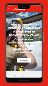
IG group, engineers and surveyors, your quality and local partner in Valais; A training company, with more than 35 years of experience, serving individuals, professionals and public authorities.
IG group, engineers and surveyors, your quality and local partner in Valais; A training company, with more than 35 years of experience, serving individuals, professionals and public authorities.
Updated on
Safety starts with understanding how developers collect and share your data. Data privacy and security practices may vary based on your use, region, and age. The developer provided this information and may update it over time.

No data shared with third parties
Learn more about how developers declare sharing

This app may collect these data types
Personal info and App info and performance

Data is encrypted in transit

You can request that data be deleted
What's new
Amélioration de l'ouverture des liens.


