ALTLAS: Trails, Maps & Hike
Contains adsIn-app purchases
4.9star
2.73K reviews
100K+
Downloads

Rated for 3+
info
About this app
Explore, record, and share your activities, Navigate any trails and GPX files using the most accurate altimeter and tracking information with the Altimeter - Activity tracker. Find hiking trails, record your activities with the GPS, and Import/export GPX trails.
Download the ultimate activity tool today!
ALT-LAS Can be used as a Bike computer use it on your bike, bicycle, scooter, and more!
By using the app you can get:
1. Elevation finder and activity tracker.
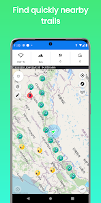
2. The app has a unique database of many trails around the world that was recorded by the users so you get the best hiking trails.
3. The app finds your altitude, peak points, barometric pressure, speed, and more!
4. The app alerts you against altitude limitations and is suitable for a variety of activities such as Walking, Trekking, Flights, Cycling, Skiing, biking, and more.
Have you ever searched for "walks near me?" or find elevation? now you can get it immediately with ALT-LAS.
Help build a community that shares routes and places around the world.
1. GPS mode: the application measures the altitude using the GPS and performs a unique correction to provide an accurate altitude.
Note, that the altitude readings may be inaccurate when the GPS signal is weak.
2. Barometer sensor (a device with a barometer sensor): the application can work with the device’s barometer sensor that is auto-calibrated with the environment.
In this mode, the application can work inside buildings without GPS.
- Track activities
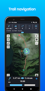
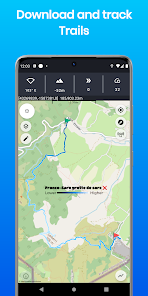
- Trail navigation
- Explore new trails
- Offline maps (Pro version)
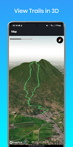
- View Trails in 3D (Pro version)
- Track your elevation
- Altimeter to get your current altitude.
- Discover and share tracks
- Weather forecast
- Elevation map
- Compass with lock bearing
- Steps & Calories calculator
- Share live location (Subscription only)
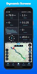
- Real-time altitude graph
- Altitude limit alerts
- Save landmarks
- Barometric pressure
- Import/export GPX files
- Climbing information
- The Altimeter can work offline (flight mode)
- Get indoor/outdoors altitude
- Periodic altitude voice notification
- Different map types: Topographic, Open Street Map, hike & bike, and Satellite (Premium only).
- Sensor info (Supported devices only) such as Barometer, Temperature, Light, and Humidity.
- Dark mode
- Measure route and vertical distance
- Routing: get the fastest route between any location to another.
- Get coordinates on the map
- Estimate time of arrival
- Circular boundary
For any questions or suggestions, feel free to contact us:
Check the Telegram channel where you can ask questions, and ideas, request features, share your activities, and more: https://t.me/ALTLASAPP
User Manual & FAQ
https://altlas-app.com/support.html
Customer support:
erol1apps@gmail.com
Website:
www.altlas-app.com
Download the app now and get started!
The use of this app or any of its content is at your own risk.
If you liked the app, please rate it!
Download the ultimate activity tool today!
ALT-LAS Can be used as a Bike computer use it on your bike, bicycle, scooter, and more!
By using the app you can get:
1. Elevation finder and activity tracker.
2. The app has a unique database of many trails around the world that was recorded by the users so you get the best hiking trails.
3. The app finds your altitude, peak points, barometric pressure, speed, and more!
4. The app alerts you against altitude limitations and is suitable for a variety of activities such as Walking, Trekking, Flights, Cycling, Skiing, biking, and more.
Have you ever searched for "walks near me?" or find elevation? now you can get it immediately with ALT-LAS.
Help build a community that shares routes and places around the world.
Measuring altitude modes:
1. GPS mode: the application measures the altitude using the GPS and performs a unique correction to provide an accurate altitude.
Note, that the altitude readings may be inaccurate when the GPS signal is weak.
2. Barometer sensor (a device with a barometer sensor): the application can work with the device’s barometer sensor that is auto-calibrated with the environment.
In this mode, the application can work inside buildings without GPS.
Features:
- Track activities
- Trail navigation
- Explore new trails
- Offline maps (Pro version)
- View Trails in 3D (Pro version)
- Track your elevation
- Altimeter to get your current altitude.
- Discover and share tracks
- Weather forecast
- Elevation map
- Compass with lock bearing
- Steps & Calories calculator
- Share live location (Subscription only)
- Real-time altitude graph
- Altitude limit alerts
- Save landmarks
- Barometric pressure
- Import/export GPX files
- Climbing information
- The Altimeter can work offline (flight mode)
- Get indoor/outdoors altitude
- Periodic altitude voice notification
- Different map types: Topographic, Open Street Map, hike & bike, and Satellite (Premium only).
- Sensor info (Supported devices only) such as Barometer, Temperature, Light, and Humidity.
- Dark mode
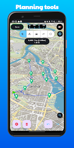
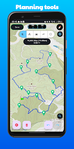
Planning and Navigation tools:
- Measure route and vertical distance
- Routing: get the fastest route between any location to another.
- Get coordinates on the map
- Estimate time of arrival
- Circular boundary
SUPPORT:
For any questions or suggestions, feel free to contact us:
Check the Telegram channel where you can ask questions, and ideas, request features, share your activities, and more: https://t.me/ALTLASAPP
User Manual & FAQ
https://altlas-app.com/support.html
Customer support:
erol1apps@gmail.com
Website:
www.altlas-app.com
Download the app now and get started!
The use of this app or any of its content is at your own risk.
If you liked the app, please rate it!
Updated on
Safety starts with understanding how developers collect and share your data. Data privacy and security practices may vary based on your use, region, and age. The developer provided this information and may update it over time.


Ratings and reviews
4.9
2.69K reviews

Ján Florovič
- Flag inappropriate
February 21, 2024
Very good app! ❤️ but showing wrong altitude. And the subscription is expensive for a few trips I make within a year 🥺

Michael Gut
- Flag inappropriate
December 23, 2023
I liked this app, one of the best for hiking. Unfortunately, it also aids "interested parties" use my data for "legitimate interest". It is possible to disable this by scrolling through I don't know how many buttons and switch them off. Do you honestly think I will go through that charade every time I use the app? Right, I thought so. Therefore uninstalled.
6 people found this review helpful
Erol1Apps
December 23, 2023
We understand how annoying that must be. We're working on a solution. We hope you'll re-consider the rating once we fix the issue.
Update: we added an option to cancel it with a button.

Aharon Gina
- Flag inappropriate
- Show review history
April 9, 2024
new version improved a lot, missing integration with strava force the use of a garmin device or similar.
2 people found this review helpful
Erol1Apps
March 26, 2022
Why review so badly for an app that helps many people? This app is for experts. if you don't know how to use it, use another app. You had the option to ask for help instead.
What's new
1. Improved the metrics values to be more precise.
2. Fixed the view of trail details with images.
3. Trail suggestions are now shown according to the user preferences.
4. Bugs fixes.
Do you have any issues or suggestions? Write to us erol1apps@gmail.com - we appreciate your feedback!


