
LK8000 Beta
1K+
Downloads

Everyone
info

About this app
This is the beta testing version of LK8000.
LK8000 is a Tactical Flight Navigator for gliders, paragliders, hang-gliders and general aviation. It is a consolidated open-source project born in 2010, available on most platforms: PC, PNA, KOBO, LINUX, IOS (under development), RASPBERRY and ANDROID. LK is translated into 17 languages and used in over 67 countries by many thousands pilots every day.
LK can be configured to act as a navigator for free flight (gliding, paragliding, hang-gliding), for light aircraft (general aviation), and also for trekking and offroad! On our website you can download the necessary maps for your country, together with documentation, hints, tutorials and news. We also offer free support to all users on our international support forum (upon free subscription). Maps can also be downloaded from LK configuration using LKMAPS app.
In addition to classic flight navigation functions, LK has many advanced features:
- Detection of start of free flight (both towing and winching)
- Accurate calculations of scoring, due to the above feature
- Forecasting for completion of FAI triangles, with virtual waypoint created dinamically and available for a "go-to"
- The Oracle, a no-panic instant page giving accurate position report for a quick readout on the radio
- A super complete automatic logbook, both for reading on the device and for export as CSV for spreadsheets.
- A clever profile system allowing saving and loading setting for device, pilot, system and aircraft
- Textual pages for waypoints, airports, airspaces, in a format similar to the one in use by professional avionics
- A super aggressive FLARM data management, with "link to target" functionalities, radar with history of traces and more. It is the most advanced FLARM data management available worldwide in terms of capabilities.
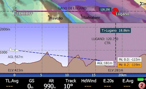
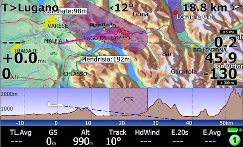
- Cross-section map pages with splittable sections (top and side view)
- An innovative "visual glide" page, suggesting all reasonable choices for long glides around with no need to touch anything, totally automatic: just feed LK with data (waypoints) about mountain peaks, valleys, ridges.
- Airspace warning sonar: approaching to airspaces can be signalled with a sonar-style approach, no need to look at the screen
- Automatic MacCready calculation (AutoMC): let us tell you how things are really going, and calculate arrival altitudes not around what you hope, but what you are really doing.
- Automatic radio frequency setup, no need to touch the radio anymore (for supported hardware)
- Multi targets: change destination with a single touch of the screen corner, rotating among current task waypoint, best alternate (calculated automatically of course), Home, Last good thermal, Team mate, Flarm target.
- Textual list and selection of all of your thermals, for a prompt go-to, automatically named after their timestamp, with distance and direction from you, historic climb average and forecasted arrival altitude at the bottom of the thermal, all sortable, and ready for a go-to .
.. and much more.
Watchout, LK8000 has been carefully designed for a turbulence proof usage during flight. It is trivial to use it, but not immediate without knowing how it works. Once you know it, you never leave it.
Feed LK with waypoints. On ancient hardware, we made LK capable to handle as much as 10 thousands waypoints at once. On modern systems, it would be a pity not to make use of hardware speed. If you fly in mountain areas, look after a waypoint list of peaks, valleys, ridges, thermal spots, and let LK use them for you. You will be amazed for what appears automatically on the multimap page "Visual glide" once there's some data to munch!
What you get, is the most advanced free flight computer ever made. Welcome aboard!
LK8000 is a Tactical Flight Navigator for gliders, paragliders, hang-gliders and general aviation. It is a consolidated open-source project born in 2010, available on most platforms: PC, PNA, KOBO, LINUX, IOS (under development), RASPBERRY and ANDROID. LK is translated into 17 languages and used in over 67 countries by many thousands pilots every day.
LK can be configured to act as a navigator for free flight (gliding, paragliding, hang-gliding), for light aircraft (general aviation), and also for trekking and offroad! On our website you can download the necessary maps for your country, together with documentation, hints, tutorials and news. We also offer free support to all users on our international support forum (upon free subscription). Maps can also be downloaded from LK configuration using LKMAPS app.
In addition to classic flight navigation functions, LK has many advanced features:
- Detection of start of free flight (both towing and winching)
- Accurate calculations of scoring, due to the above feature
- Forecasting for completion of FAI triangles, with virtual waypoint created dinamically and available for a "go-to"
- The Oracle, a no-panic instant page giving accurate position report for a quick readout on the radio
- A super complete automatic logbook, both for reading on the device and for export as CSV for spreadsheets.
- A clever profile system allowing saving and loading setting for device, pilot, system and aircraft
- Textual pages for waypoints, airports, airspaces, in a format similar to the one in use by professional avionics
- A super aggressive FLARM data management, with "link to target" functionalities, radar with history of traces and more. It is the most advanced FLARM data management available worldwide in terms of capabilities.
- Cross-section map pages with splittable sections (top and side view)
- An innovative "visual glide" page, suggesting all reasonable choices for long glides around with no need to touch anything, totally automatic: just feed LK with data (waypoints) about mountain peaks, valleys, ridges.
- Airspace warning sonar: approaching to airspaces can be signalled with a sonar-style approach, no need to look at the screen
- Automatic MacCready calculation (AutoMC): let us tell you how things are really going, and calculate arrival altitudes not around what you hope, but what you are really doing.
- Automatic radio frequency setup, no need to touch the radio anymore (for supported hardware)
- Multi targets: change destination with a single touch of the screen corner, rotating among current task waypoint, best alternate (calculated automatically of course), Home, Last good thermal, Team mate, Flarm target.
- Textual list and selection of all of your thermals, for a prompt go-to, automatically named after their timestamp, with distance and direction from you, historic climb average and forecasted arrival altitude at the bottom of the thermal, all sortable, and ready for a go-to .
.. and much more.
Watchout, LK8000 has been carefully designed for a turbulence proof usage during flight. It is trivial to use it, but not immediate without knowing how it works. Once you know it, you never leave it.
Feed LK with waypoints. On ancient hardware, we made LK capable to handle as much as 10 thousands waypoints at once. On modern systems, it would be a pity not to make use of hardware speed. If you fly in mountain areas, look after a waypoint list of peaks, valleys, ridges, thermal spots, and let LK use them for you. You will be amazed for what appears automatically on the multimap page "Visual glide" once there's some data to munch!
What you get, is the most advanced free flight computer ever made. Welcome aboard!
Updated on
Safety starts with understanding how developers collect and share your data. Data privacy and security practices may vary based on your use, region, and age. The developer provided this information and may update it over time.

No data shared with third parties
Learn more about how developers declare sharing

No data collected
Learn more about how developers declare collection
What's new
* fix :
- android usb/serial port
- possible app freeze on comport restart
- "Air Control Display" : workaround to set active channel
* new :
- add FFVL tracking system
- android usb/serial port
- possible app freeze on comport restart
- "Air Control Display" : workaround to set active channel
* new :
- add FFVL tracking system