
onX Backcountry Trail Maps GPS
In-app purchases
4.5star
998 reviews
100K+
Downloads

Everyone
info


About this app
Meet the ultimate GPS map app for your outdoor pursuits. onX Backcountry lets you easily find and navigate the trails you're looking for—whether you’re seeking out new backcountry ski lines, climbing routes, or trails to hike and mountain bike. Make a plan with the best maps with the most trustworthy trail information, and navigate confidently even without cell service with offline maps and GPS tracking on the trail.
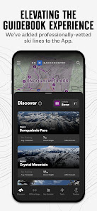
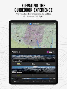
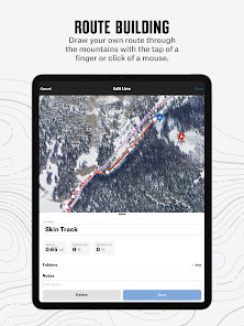
▶Discover New Adventures With Comprehensive Trail and Ski Line Information
Whether you’re looking to navigate a ski tour, hike, run, mountain bike, or backpacking trip, we’ve got you covered. With over 650,000+ miles of trails. 4,000+ ski routes, 300,000+ rock climbs, and our maps will help you discover trails and adventures nearby.
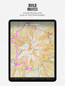
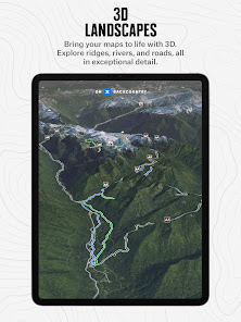
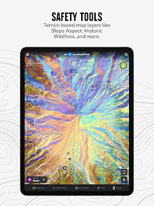
▶Prep Better For Your Outings With Powerful Map Tools
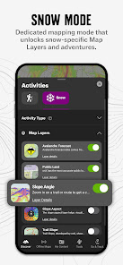
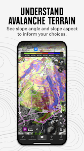
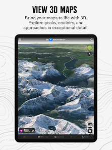
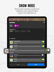
We adventure in three dimensions, your maps should reflect that. With a 3D map you can visualize terrain, scout ski lines, and plan for hazards before you hit the trail. See recent conditions with weather forecasts, reports from other trail users, and get winter snow info from SNOTEL stations and regional avalanche forecasts right on your map. Map out custom routes seamlessly with snap-to-trail functionality, and use Waypoints Slope Angle, Slope Aspect, Trail Slope, and WildfireLayers to plan in more granular detail.
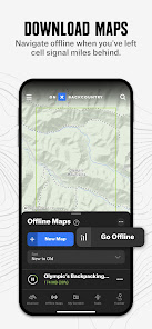
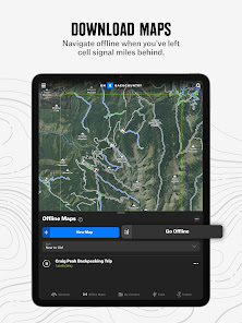
▶Navigate Without Cell Coverage
Save Offline Maps to bring your custom maps along when you're outside cell coverage on the trail. With the onX Backcountry App, you turn your phone into a handheld GPS maps device using your phone's internal GPS. Navigate offline by following the blue dot to always know how to get home–wherever home is that night. Leave a breadcrumb trail with Tracker to see where you’ve been and measure your key trip stats.
▶The Best Maps, Period.
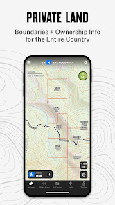
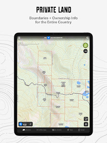
With map data sourced from USFS, BLM, and NPS, our color-coded base maps help you easily find what you’re looking for. Scout the landscape and visualize terrain by viewing your maps in 3D, topo, satellite imagery, or a hybrid. Elite users also get access to private land owner data and recent satellite imagery to hit the trail even more informed.
▶ PREMIUM AND ELITE BACKCOUNTRY APP FEATURES:
▶650,000+ miles of running trails, hiking trails, backpacking trails, and mountain bike trails
▶4,000+ backcountry ski lines with guidebook descriptions
▶300,000+ rock climbing routes as well as approach trails
▶Snap-to-trail route builder to plan trips and see distance and elevation gain in seconds
▶Save unlimited Offline Maps for offline navigation without cell service
▶GPS tracking your trips to know where you came from, how to get back, and share your adventure with friends
▶ Localized weather conditions and 7-day weather forecasts
▶24K topographic maps and 3D maps for the entire U.S.
▶985 million acres of Public Land across the U.S.
▶550,000 Recreation Icons for points of interest, including trail heads, backcountry cabins and lookouts, campgrounds & dispersed camping land
▶Avalanche forecasts for the U.S. and Canada
▶Recent snowfall information & historic trends via SNOTEL data
▶ The best GPS trail maps to navigate on your next backcountry ski, hike, climbing, and biking
▶Private Land Layer-ELITE ONLY: Nationwide private property maps and land boundaries, land ownership information, and acreage
▶Recent Imagery-ELITE ONLY: Detailed satellite imagery from the past two weeks
▶ Free Trial
While the onX Backcountry App and many of its map features are free, you’ll start a free Premium or Elite trial when you install the App. This allows you to try many of our best features, like 3D maps, unlimited offline downloads, trail info, and guidebook backcountry ski lines. After the first seven days, you’ll still have access to beautiful topographic and satellite maps, GPS tracking, weather, and more.
▶ FEEDBACK
If you have any trouble or have an idea on what you’d like to see in the maps next, please contact us at support@onxmaps.com. We’d love to hear from you.
▶Discover New Adventures With Comprehensive Trail and Ski Line Information
Whether you’re looking to navigate a ski tour, hike, run, mountain bike, or backpacking trip, we’ve got you covered. With over 650,000+ miles of trails. 4,000+ ski routes, 300,000+ rock climbs, and our maps will help you discover trails and adventures nearby.
▶Prep Better For Your Outings With Powerful Map Tools
We adventure in three dimensions, your maps should reflect that. With a 3D map you can visualize terrain, scout ski lines, and plan for hazards before you hit the trail. See recent conditions with weather forecasts, reports from other trail users, and get winter snow info from SNOTEL stations and regional avalanche forecasts right on your map. Map out custom routes seamlessly with snap-to-trail functionality, and use Waypoints Slope Angle, Slope Aspect, Trail Slope, and WildfireLayers to plan in more granular detail.
▶Navigate Without Cell Coverage
Save Offline Maps to bring your custom maps along when you're outside cell coverage on the trail. With the onX Backcountry App, you turn your phone into a handheld GPS maps device using your phone's internal GPS. Navigate offline by following the blue dot to always know how to get home–wherever home is that night. Leave a breadcrumb trail with Tracker to see where you’ve been and measure your key trip stats.
▶The Best Maps, Period.
With map data sourced from USFS, BLM, and NPS, our color-coded base maps help you easily find what you’re looking for. Scout the landscape and visualize terrain by viewing your maps in 3D, topo, satellite imagery, or a hybrid. Elite users also get access to private land owner data and recent satellite imagery to hit the trail even more informed.
▶ PREMIUM AND ELITE BACKCOUNTRY APP FEATURES:
▶650,000+ miles of running trails, hiking trails, backpacking trails, and mountain bike trails
▶4,000+ backcountry ski lines with guidebook descriptions
▶300,000+ rock climbing routes as well as approach trails
▶Snap-to-trail route builder to plan trips and see distance and elevation gain in seconds
▶Save unlimited Offline Maps for offline navigation without cell service
▶GPS tracking your trips to know where you came from, how to get back, and share your adventure with friends
▶ Localized weather conditions and 7-day weather forecasts
▶24K topographic maps and 3D maps for the entire U.S.
▶985 million acres of Public Land across the U.S.
▶550,000 Recreation Icons for points of interest, including trail heads, backcountry cabins and lookouts, campgrounds & dispersed camping land
▶Avalanche forecasts for the U.S. and Canada
▶Recent snowfall information & historic trends via SNOTEL data
▶ The best GPS trail maps to navigate on your next backcountry ski, hike, climbing, and biking
▶Private Land Layer-ELITE ONLY: Nationwide private property maps and land boundaries, land ownership information, and acreage
▶Recent Imagery-ELITE ONLY: Detailed satellite imagery from the past two weeks
▶ Free Trial
While the onX Backcountry App and many of its map features are free, you’ll start a free Premium or Elite trial when you install the App. This allows you to try many of our best features, like 3D maps, unlimited offline downloads, trail info, and guidebook backcountry ski lines. After the first seven days, you’ll still have access to beautiful topographic and satellite maps, GPS tracking, weather, and more.
▶ FEEDBACK
If you have any trouble or have an idea on what you’d like to see in the maps next, please contact us at support@onxmaps.com. We’d love to hear from you.
Updated on
Safety starts with understanding how developers collect and share your data. Data privacy and security practices may vary based on your use, region, and age. The developer provided this information and may update it over time.


Ratings and reviews
4.5
971 reviews

Sas Quatch
- Flag inappropriate
- Show review history
March 1, 2024
UPDATE: It was awuful a couple years ago, but after trying it yet again, I find it has improved dramatically and is now one of the best mapping programs I use. I have changed the rating from 2 stars to 5. They seem to have addressed all the issues I had with it, from accuracy, depency on being online for good functionality to the weird pop up menu behaviors. It is now smooth, accurate, the map choices are excellent, it is more user friendly and works far better offine. Weather features are great
124 people found this review helpful
onXmaps
March 4, 2024
Thanks for the support!

Jeff Killitz
- Flag inappropriate
March 7, 2024
Had an issue with the tracker function not working properly after a recent update. I summited a trouble ticket. I received a response in about four hours. They told me how to check all the associated settings on my Samson Z fold phone. All setting were correct. The next day I got a another updated download and the Tracker function started working correctly. Great trouble response service and very timely. I been an onX user for over 5 years and just recently upgraded to the Elite level.
25 people found this review helpful
onXmaps
March 7, 2024
Hey Jeff,
Thank you for rating onX Backcountry. We're pleased to hear you had an interaction with our support team. It's awesome to hear you utilize the tracker function, it's such an awesome feature. We hope you have some grand adventures planned for this spring.
Happy Mapping,

Shawn Meier
- Flag inappropriate
January 30, 2024
Just got a subscription for use with back country skiing. So far it seems pretty good. My only complaints are: 1) the interface for downloading maps is kinda weird limiting the downloadable area, 2) it's kinda hard to measure a linear distance on the map and 3) I wish the basic subscription had a little more info on private land ownership.
33 people found this review helpful
onXmaps
February 2, 2024
Hello,
Thank you for taking the time to rate onX Backcountry. We will certainly pass along your feedback. If you have any questions, please feel free to reachout to help@onxmaps.com.
Regards,


