
Waterlevels Voss
100+
Downloads

PEGI 3
info

About this app
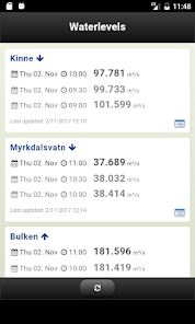
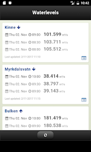
Waterlevels shows the flow for selected rivers in Voss, Norway. The latest observations are displayed for each river, allowing you to see how fast the waterlevel goes up or down. You can click the river name and get the levels for the last 24-48 hours. All data are fresh and live from NVE, Norges Vassdrags og Energidirektorat.
Updated on
Safety starts with understanding how developers collect and share your data. Data privacy and security practices may vary based on your use, region, and age. The developer provided this information and may update it over time.

No data shared with third parties
Learn more about how developers declare sharing

No data collected
Learn more about how developers declare collection
What's new
Upgraded to sildre.nve.no api. Added stations for Teigdalselvi and Strandaelvi.
