TaPP n Go
500+
Downloads

Everyone
info
About this app
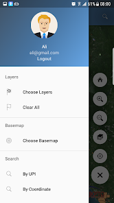
N Go App developed to help authorities manage the land JKPTG PTP particularly in the application and acquisition of land. Using the ArcGIS platform, users can obtain spatial and non-spatial information updates provided by ArcGIS Server. The application offers several functions to facilitate enforcement JKPTG. Among the functions offered are:
- Map View
- Land Information Display
- Land Search by No JKPTG or UPI
- Search by coordinates
- Navigation
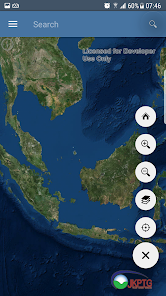
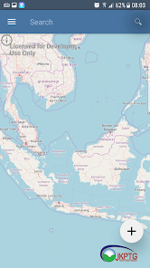
Map interesting
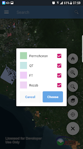
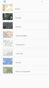
View a map of the base map has a gallery ArcGIS. This function allows the user to change the map view basis according to user requirements. In addition to the basic map, another map layer that appears over the base map is a land of PTP-status application, QT, FT, and Reserves. The basic functionality for map display functions are also available such as zoom in, zoom out, the default view, the current location, and map directions.
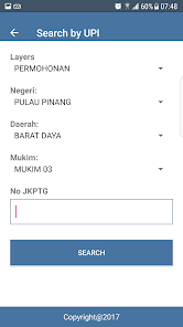
search
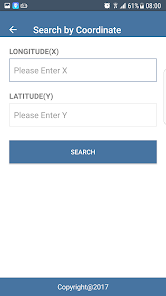
In addition to the map view, users can also search the land PTP as needed. Two search options are available, namely Search by No JKPTG or UPI, and Search by coordinate. Results will appear directly on the map display.
Navigate to the ground PTP
The application also allows users to use the navigation function to the desired PTP land. Navigation will get the user's current location as a starting point and a destination location PTP land. Navigation function uses Google Map Navigation as a platform.
- Map View
- Land Information Display
- Land Search by No JKPTG or UPI
- Search by coordinates
- Navigation
Map interesting
View a map of the base map has a gallery ArcGIS. This function allows the user to change the map view basis according to user requirements. In addition to the basic map, another map layer that appears over the base map is a land of PTP-status application, QT, FT, and Reserves. The basic functionality for map display functions are also available such as zoom in, zoom out, the default view, the current location, and map directions.
search
In addition to the map view, users can also search the land PTP as needed. Two search options are available, namely Search by No JKPTG or UPI, and Search by coordinate. Results will appear directly on the map display.
Navigate to the ground PTP
The application also allows users to use the navigation function to the desired PTP land. Navigation will get the user's current location as a starting point and a destination location PTP land. Navigation function uses Google Map Navigation as a platform.
Updated on
Data safety
Developers can show information here about how their app collects and uses your data. Learn more about data safety

No information available
What's new
- Upgrade SDK version.


