


This app is used to indicate position of hazard and direction of safe water
Cardinal Marks are used for permanent wreck marking whereby North, East, South and West Cardinal buoys are placed around the wreck.
Cardinal marks are named after the four quadrants of compass i.e. North, South, East, and West. These are buoys placed mid sea and indicate that safe water lies to the named side of the mark.
A navigator will be safe if the vessel passes north of a north mark, south of a south mark, east of an east mark and west of a west mark.
This app has been developed as a quick reference guide. The mobile can be placed horizontally or held vertically for the heading to follow up.
Unique feature of this app is the ECDIS view. Shortly we will be including the light signals displayed during darkness. New features will be developed as we get suggestions.

Morse Code from Bhandarkar Publications is your standalone app for Morse code...

Adoption: 1973 (Convention), 1978 (1978 Protocol), 1997 (Protocol - Annex VI); Entry...

The book is divided into three sections. The first section deals with...

NATH - Nautical Almanac 1992, ASTM tables – Selected pages, Tide Tables...
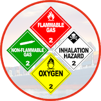
Handling and Shipping dangerous goods is a very dangerous business if not...

Handling and Shipping dangerous goods is a very dangerous business if not...
Created with AppPage.net
Similar Apps - visible in preview.