Vriray
Seismic earthquake monitoring, early warning analysis, and BLE (Body-Light Explosive Debris) rescue radar platform.

About Vriray
GOVERNMENT DISCLAIMER:
Vriray is an independent disaster monitoring platform. It does not represent the Ministry of Interior of the Republic of Turkey, AFAD, Kandilli Observatory, or any other official public institution; it is not an official public organization. The seismic data presented in the application is compiled from publicly available official institution data streams.
OFFICIAL DATA SOURCES AND VERIFICATION LINKS:
Original official public sources of seismic data used in the application:
• Republic of Turkey Ministry of Interior AFAD Earthquake Department: https://deprem.afad.gov.tr
• Republic of Turkey Ministry of Interior AFAD Official Portal: https://www.afad.gov.tr
• Boğaziçi University Kandilli Observatory (KRDAE): http://www.koeri.boun.edu.tr
• USGS (United States Geological Survey): https://earthquake.usgs.gov
--------------------------------------------------
Vriray is a next-generation disaster monitoring and rescue platform that monitors seismic activity in real-time, provides early warning analysis, and assists in locating individuals under rubble using Bluetooth Mesh during network outages.
KEY MODULES AND CAPABILITIES:
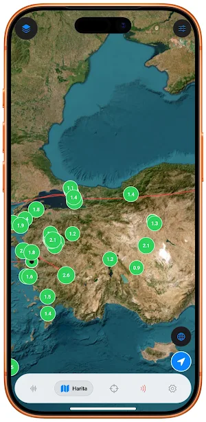
1. REAL-TIME SEISMIC MONITORING AND OFFICIAL DATA FLOW
• AFAD, Kandilli Observatory, and USGS data are compiled and listed in real-time. • Magnitude (Mw, Ml), depth, epicenter, and straight-line distance to your current location are calculated.
• Customized seismic scanning is performed according to province, district, and magnitude thresholds.
2. GOOGLE EARTHQUAKE ANALYSIS SYSTEM AND P/S WAVE ESTIMATION (GMPE)
• Prediction engine that calculates the difference between primary (P) and secondary (S) wave velocities.
• Ground acceleration models (GMPE) and the Mercalli scale analyze the duration and intensity of the tremor that will reach your location.
• Generates an audible and visual early warning timer that wakes up the screen during critical tremors.
• Provides support for micro-tremor detection via the device's accelerometer.
3. OFFLINE BLE MESH DEBRIS RESCUE RADAR
• Operates with Bluetooth Low Energy (BLE) signals during disasters when the GSM network and internet have collapsed. • Calculates the estimated distance, direction, and battery status of the victim using the Log-Distance Path Loss model. • Provides guidance to teams searching under the rubble with audible and vibrating search support.
4. OFFICIAL DISASTER ASSEMBLY AREAS AND ACTIVE FAULT LINES
• Lists the nearest official disaster assembly areas to your location on the map with route guidance.
• Visualizes the active fault lines of the North Anatolian Fault (NAF), East Anatolian Fault (EAF), and West Anatolian Fault (WAF).
5. EMERGENCY SOS AND PHYSICAL ASSISTANCE SYSTEM
• High-decibel emergency Morse code siren and flashing light signal that works with a single touch.
• Local BLE emergency broadcast containing location and status information of users trapped under rubble. • Infrastructure for sending SMS messages and sharing coordinates to registered relatives with a single touch in case of emergency.
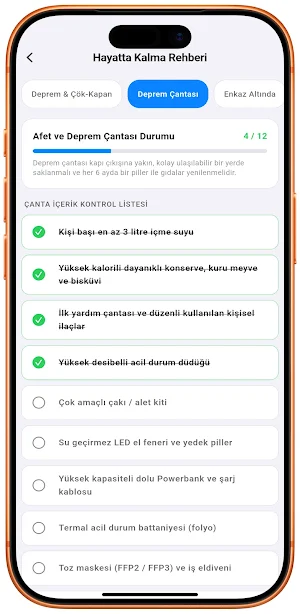
6. OFFLINE SURVIVAL GUIDE AND DISASTER KIT
• Illustrated disaster protocols that work without internet (Drop-Cover-Hold On, Fire, Tsunami, First Aid).
• Interactive earthquake and disaster kit checklist with status stored in memory.
7. LOW BATTERY AND MINIMAL DATA CONSUMPTION
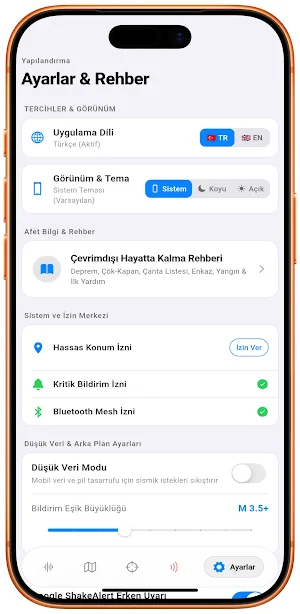
• Optimized architecture to consume minimum energy in the background.
• Compressed seismic data stream mode that saves mobile data.
• Simple interface compatible with Apple standard Light and Dark themes.
LOCATION DATA USAGE AND PROMINENT DISCLOSURE:
Vriray accesses your location data (approximate and precise GPS) only when the application is open in order to calculate earthquake distance, provide seismic early warning specific to your region, show the nearest assembly areas on the map, and share coordinates with BLE Mesh under the rubble. Your location data is processed only locally on your device; it is not transferred to any external server, shared with third parties for advertising/marketing purposes, or sold.
PRIVACY AND LEGAL TERMS:
Vriray is an independent civil software and is not an official public organization. The seismic data presented is obtained from publicly available data streams of official institutions. Early warning models are predictive in nature; they do not replace official AFAD (Disaster and Emergency Management Presidency) and emergency response protocols.
