


3D Augmented Reality Compass, GPS, Map, Landmarks,... The one-in-all solution!
AR GPS Compass Map 3D - The Augmented Reality 3D Compass with an integrated split-screen map!
Locating landmarks (e.g. via latitude / longitude) has never been easier thanks to a green arrow on top of the compass that always points towards the currently selected landmark !
Our unique fusion and filtering algorithm that combines the values of the magnetic field sensor, the accelerometer, and the gyroscope gives you a maximum in precision and stability of the compass.
A special feature is the ability to measure the height of large objects, such as houses or trees. Check it out, it's really easy.
Features:
* 3D Augmented Reality display
* High precision and stability
* Integrated split-screen map of adjustable size with GPS location
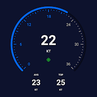
* Display various GPS information (latitude, longitude, speed, altitude, number of satellites,...)
* Measure the height of large objects (skyscrapers, trees, ...)
* Measure magnetic field strength (metal detector)
* Magnetic field strength warning (indicates magnetic influences)
* Geocaching: Easily define and find landmarks
* Share landmarks or your current location with other users
* Define landmarks by specifying latitude / longitude in various formats
* Define landmarks by a long-press on the map
* Define landmarks by specifying distance and bearing
* Supports LG’s Real3D technology for stereoscopic displays
This is the Free-Version. There is also a Pro-Version available. Please check our other apps, you can find it there :-)
Have fun :-)
Alex from CodeKonditor

Easy to use compass and spirit level application with magnetic north, coordinates,...
Mariner GPS Dashboard for Android and Wear OS calculates your speed in...

Ever felt uneasy navigating on the water? Wanted to know your boat...

Get up-to-date, detailed charts you can use offline plus a boatload of...
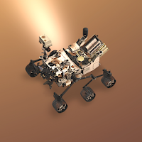
Created by NASA’s Jet Propulsion Laboratory, this stunning educational app uses native...

Compass GM is a gyro-magnetic compass app that accurately indicates true or...


Created with AppPage.net
Similar Apps - visible in preview.